|
Where Should I Go from Here?
Visit the Map
If you came to this page from an outside link, you may want to see the Picture of the Month and visit my main page. |
- Astoria, Oregon Operating Companies
Astoria, Oregon was a busy seaport, and the first permanent settlement founded by Americans west of the Rockies.
- Portland, Oregon Operating Companies
Portland Heights was a natural destination for cable traction.
- Seattle Operating Companies
Because of the steep hills East of the business district, Seattle kept its cable car lines longer than any American city except San Francisco.
- Spokane Operating Companies
Spokane's two lines were fatally injured by an economic downturn.
- Tacoma Operating Companies
Tacoma had one of the most logical layouts in the industry.
- Butte Operating Companies
Butte's single line used a shallow conduit grip.
- Pacific Northwest Miscellany
- 1941 - A Bad Year for Cable Cars
- Seattle Visit - 2010
- Seattle and Portland Counterbalances
- Steve's Gay '90s (Tacoma)
- The Skagit Incline
- Motor Ferry Kalakala (external link to my ferry web site)
- Selected Items from The Street Railway Journal
- from Correspondence (January, 1891. Volume VII, Number 1.)
- Balance Weights for Street Cars. (April, 1891. Volume VII, Number 4.)
- from Street Railway News: General (April, 1891. Volume VII, Number 4.)
- from Extensions and Improvements (June, 1891. Volume VII, Number 6.)
- Madison Street Cable Life (January, 1893. Volume IX, Number 1.)
- Balance Weights for Grades. (January, 1893. Volume IX, Number 1.)
- from Colorado Springs, Salt Lake City, Ogden, Butte, Helena, Great Falls and Spokane. (April, 1893. Volume IX, Number 4.)
- from Portland, Tacoma, Seattle, Everett, Astoria. (May, 1893. Volume IX, Number 5.)
- from Street Railway News. (May, 1893. Volume IX, Number 5.)
Astoria Cable Railway

|
The city of Astoria granted a license to the Pacific Cable Company a franchise to build a cable car line. (Source: Salem Statesman Journal, 11-February-1890, page 2). |
The city of Astoria, a booming port, gave the patent trust's Pacific Cable Company a franchise to build a cable car line. This never happened, perhaps because of the Panic of 1893, a depression worse than the Great Depression of the 1930s. I guessed at the potential company name.

|
The local Astoria newspaper was sure that the town would soon have a cable car system. (Source: Salem Statesman Journal, 18-February-1890, page 2). |
Go to top of page.
Portland Cable Railway

|
The great Portland Heights trestle. |

|
Two cars of the Portland Cable Railway pass on the trestle's 20% grade. (Source: "Portland, Tacoma, Seattle, Everett, Astoria," The Street Railway Journal, May, 1893. Volume IX, Number 5.) February, 2023 Picture of the Month. |
line: Portland Heights
opened: 22-Feb-1890. Front and Alder via Alder to 5th, 5th to Jefferson, Jefferson to 18th, 18th to Spring. Trestle on 18th from Mill to Spring.
revised: ??-Jun-1890. After a runaway, turntable moved from top of trestle around a curve so cars could take the rope on flat ground.
revised: 09-Aug-1890. 5th from Alder to Hoyt.
revised: ??-???-1891. 5th from Hoyt to Irving (Union Station). Alder Street from Front to 5th became a shuttle.
revised: 03-Nov-1891. 18th and Spring via Jefferson to Washington (now City) Park
revised: 01-May-1896. Cut back to the trestle.
powerhouse: SW 18th and Mill
grip: McLellan bottom grip. "A bottom grip is employed, which was invented by Mr. McLellan, one of the employes of the company. The jaw is twelve inches in length, and grip dies of wrought iron are employed which have a life of about three weeks. The grip is operated by hand levers from the open portion of the car and is provided with an adjustable mechanism which always insures a firm hold on the rope. The grip has operated with great satisfaction and has never failed even on the heavy grades." (Source: "Portland, Tacoma, Seattle, Everett, Astoria," The Street Railway Journal, May, 1893. Volume IX, Number 5.)
gauge: 3'6"
cars: single-ended combination cars. Double-ended combination car on Alder Street shuttle. "The cars, twenty-three in number, are all eight wheel combination, one of which has an open section at both ends. The cars are carefully designed and tastefully finished, and were manufactured by the S. C. H. & A. Works, Stockton, Cal." (Source: "Portland, Tacoma, Seattle, Everett, Astoria," The Street Railway Journal, May, 1893. Volume IX, Number 5.)
terminals: turntables
crossings:
line: King's Heights
opened: 08-Apr-1892. 5th and Irving on 5th to Jefferson. Jefferson to Canyon Road. Canyon to approximately Kingston Avenue to somewhere around about Fairview Boulevard.
cut back: ??-???-1892. Cut back to somewhere on Canyon Road when city flooded part of Washington Park for a reservoir.

|
"The cable cars have not been running today." The equipment needed some techical adjustments and the company did not have enough cars to handle regular service. The line had opened on 22-February-1890. I wonder how the trial for "criminal intimacy" turned out. (Source: Albany Democrat-Herald, 05-March-1890, page 3). |
notes: Portland's cable cars were intended to connect the low-lying downtown with growing housing developments on Portland Heights. The Portland Cable Railway was organized on 24-Jun-1887 to replace an omnibus line.

|
Bicyclist Charles Nachand filed a suit alleging that Portland Railway's cable car slot on Fifth Street was too wide, which caused his wheel to get caught and threw him to the ground. "The railway company alleges that Nachand was riding a dangerous bicycle and that the accident was due to his carelessness." (Source: Oregon Daily Journal, 12-October-1903, page 4). |
Pacific Cable's J M Thompson built the line. Harsh winter weather caused frequent slot closures and required the development of a grip with an extra-narrow shank.

|
A horse and his grocery delivery wagon somehow wound up on the trestle and ran away. "... resulting in a badly injured horse and a still worse broken up wagon." (Source: Oregon Daily Journal, 09-December-1902, page 2). |
The line's steep trestle became a local landmark. "On Chapman Street the road scales a high bluff by means of a high trestle 1,300 ft. in length with a grade of 20 per cent. (Fig. 9), and continues above the trestle for a considerable distance over steps ranging from 12 to 20 per cent., making a rise of 450 ft. in a distance of 2,600 ft., the terminal being 600 ft. above the river. From the highest point the road turns to the right and runs along the mountain for a considerable distance to the terminal, where is located a turntable on which the cars are turned by hand for the return trip. It was the intention of the original promoters to continue the line to the top of the mountain some little distance beyond, but the section has never been completed. " (Source: "Portland, Tacoma, Seattle, Everett, Astoria," The Street Railway Journal, May, 1893. Volume IX, Number 5.)
The company's cars were built in California by the Stockton Combine, Harvester & Agricultural Works. They closely resembled the cars of San Francisco's Ferries & Cliff House Railway.
Through a series of mergers, the cable system came under the ownership of the Portland Railway Company. Portland Railway electrified the flat portions of the line, keeping cable traction only on the trestle. Cable cars continued to climb the trestle, connecting with electric cars, until 1904, when Portland Railway Company opened the famous Council Crest electric streetcar line along Vista avenue.
The web site of Tri-Met, the Portland Oregon region's public transit agency, has a page about the Portland Cable Railway.
Council Crest car 503 ran in San Francisco as part of the 1983 Vintage Trolley Festival. It was exciting to ride down Market Street in a car without air brakes.

|
Open car. |

|
Portland Cable Railway closed car. February, 2003 Picture of the Month. |

|
Read more about the Portland Cable Railway in an interesting article from The Street Railway Journal. This illustration, looking up the great trestle from the powerhouse, comes from the article. (Source: "Portland, Tacoma, Seattle, Everett, Astoria," The Street Railway Journal, May, 1893. Volume IX, Number 5.) February, 2013 Picture of the Month. |

|
Portland cable car converted to electric. |

|
The Oregon Daily Journal published a "Visitors' Guide to Portland and Vicinity." "Portland Heights -- Great elevation, exciting car ride on cable car, extensive view of the city and Willamette and Columbia Rivers. Take Fifth-street cars, transferring to cable." (Source: Oregon Daily Journal, 17-April-1902, page 8). |

|
Auto dealers liked to use big hills to demonstrate the power of their vehicles. In this case, a Cadillac climbed the great incline, turned around drove down. (Source: Oregon Daily Journal, 17-March-1904, page 12). |
Go to top of page.
Seattle City Railway

|
Yesler Way grip car preserved at the Smithsonian Institution. Used with permission of the Smithsonian Institution. Jan, 1998 Picture of the Month. |
line: Yesler Way
opened: 27-Sep-1888. One-way Yesler East to Lake Washington, Jackson West to 2nd Avenue, to Yesler. High trestles down on Yesler & up on Jackson to the lake.
revised: 1890. Two ways on Yesler trestle, Rainer Avenue to Jackson. Inspired by serious accident on cheaply built Jackson trestle on 17-Aug-1890.
revised: 1899-1900. Two ways on Yesler.
revised: 1920. Cut back from Occidental to Prefontaine Place.
powerhouse: Near Lake Washington, about Power Avenue.
powerhouse: At Lake Washington.
grip: Single-jaw side grip.
gauge: 3'6"
cars: single-ended dummy & trailer trains.
Later, double-end California cars. Enclosed during the teens.
turntables: ?
crossings:
notes:
Yesler Way was Seattle's most famous cable car line. It connected Pioneer Square, near the Puget Sound waterfront, with high-lying residential districts and the Leschi recreational area near Lake Washington. Ferries operated from Leschi to Medina and Bellevue.
When the line was built, the residential and recreational areas did not exist and the area was almost completely uninhabited. All of the Seattle cable railways were promoted by real estate developers. Here is a list of the people who were involved in some or all of them:
| Name | SCR | FSCR | MSCR | WSCR | UTL | Comments |
| Ewing, Thomas | - | - | - | Y | - | Developer |
| Furth, Jacob | - | Y | Y | - | - | Developer |
| Grayson, George W | - | - | - | Y | - | Developer |
| Haines, J C | Y | Y | Y | - | - | Developer |
| Hunt, L S J | Y | - | - | - | - | Developer |
| King, Homer | - | - | - | Y | - | Developer |
| Leary, John | Y | - | - | - | - | Developer |
| Low, Josiah O | Y | - | - | - | - | Developer |
| McGilvra, John J | - | - | Y | - | - | Developer |
| McMicken, Maurice | - | Y | Y | - | - | Developer |
| Metcalfe, J B | Y | - | - | - | - | Developer |
| Mitten, A P | - | Y | Y | - | - | Developer |
| Moore, A S | Y | - | - | - | - | Developer |
| Moore, George A | Y | - | - | - | - | Developer |
| Rochester, Junius | Y | - | - | - | - | Developer |
| Sander, Fred | Y | - | - | - | Y | Developer |
| Stewart, A B | - | Y | Y | - | - | Developer |
| Struve, H G | - | - | Y | Y | - | Developer |
| Thompson, J M | Y | Y | Y | Y | - | Engineer/Promoter |
The line was promoted by the Seattle Construction Company, with the help of the patent trust's Pacific Cable Construction Company. It was designed and built by Pacific Cable's J M Thompson. Because the company was insufficiently capitalized, the Construction Company operated it until the Lake Washington Cable Railroad purchased it in 1889. Fred Sander, the new owner, developed the recreational facilities at Leschi Park. In 1890, Sander sold it to new owners who created the Seattle City Railway. The Seattle City Railway went bankrupt in 1893 and was sold in foreclosure to the Seattle Electric Company, which had acquired most of the city's transit lines, in 1901. The city of Seattle took over the whole system in 1919, forming the Seattle Municipal Street Railway.
The cable line was converted on 10-Aug-1940 when buses that could handle the grades became available and a New Deal Reconstruction Finance Corporation loan made the funds available to convert all of Seattle's cable and electric streetcar lines.
An iron pergola that served as the Yesler Way and James Street lines' terminal survives in Pioneer Square, near the famous Tlingit Indian Totem Pole. The pergola was designed by Julian Everett and built in 1909. It also served as the entrance to and elaborate underground restroom. The pergola marks the site of Henry Yesler's saw mill, the birthplace of Seattle. The Pergola was seriously damaged by a t ruck on 15-Jan-2001. It had to be completely rebuilt and was rededicated on 17-Aug-2002.
The city purchased Leschi Park in 1909.
The cable was steam powered until 03-Jun-1912, when the powerhouse was converted to use electric motors.

|
Looking up Second Avenue at Yesler. An enclosed Yesler Way car crosses in the foreground. The cars were enclosed during the teens. |

|
There was discussion about the use of buses to replace the Yesler Way cable line. Some people felt that Diesel buses could not handle the hills at the western end. It would take a while before the overhead for trolley coaches could be installed. (Source: Seattle Star, 19-March-1940, page 11). |

|
Some people suggested that the buses intended to replace the Yesler Way cable line should use the cable line's trestle at the Leschi end. (Source: Seattle Star, 22-March-1940, page 4). |

|
An announcement says that the Yesler Way cable line will be converted to buses in July. (Source: Seattle Star, 21-June-1940, page 4). |

|
The last run on Seattle's Yesler Way cable line. (Source: The Olympian, 11-August-1940, page 1). |

|
Peter Erhlich took this photo at the Yesler Way Station in November, 2008. The sign gives the history of the cable car line. The excavated terminal sheave is on display in the mezzanine. Peter Ehrlich photo. All rights reserved. |

|
An exhibit in the Pioneer Square light rail station includes the terminal sheave of the Yesler Way line, which had been excavated in 1990. Read more about our July, 2010 visit to Seattle. |
Go to top of page.
Front Street Cable Railway
line: Front Street
opened: 13-Mar-1889. Continental Street (1st Avenue) from King to Front. Front to Pike, Pike to 2nd Avenue, 2nd to Poplar (2nd Street), High to Temperence (Queen Anne), to Farragut (Highland). Return, Pine from 2nd to Front.
powerhouse: Front & Poplar.
grip: Single-jaw side grip.
gauge: 4'8 1/2"
cars: single-ended dummy & trailer trains.
turntables: At terminii
crossings:
| Intersection | Company | Status |
|---|---|---|
| Front/Madison | MSCRY | inferior |
notes:
The Front Street Cable Railway was Seattle's only north-south line. It ran near the waterfront and up residential Queen Anne Hill. It was designed by J M Thompson of Pacific Cable.
The line was poorly built. The conduit of the northern part of the line was built of wood. The line suffered from the consequences of its cheap construction and from competition from a parallel electric line on Second Avenue. The line was taken over by the Seattle Electric Company in 1900. Most of the cable operation was converted to electric on 04-Sep-1900.
The only major gradient, on Queen Anne Hill, was replaced by a counterbalance to assist electric streetcars between Mercer and Galer. The cars were counterbalanced by a 16-ton weight which ran on rails in the conduit. Apparently, a half block of conduit at the bottom was filled with sawdust to cushion the weight in case it broke loose. The counterbalance was replaced by trolley buses on 02-Sep-1940.
To persuade voters to pass a measure to replace electric and cable streetcars with trolley buses, the Seattle Municipal Street Railway staged a race between a trackless trolley running under temporary wires and a streetcar on the counterbalance. "...(T)he modern trackless coach embarrassed the Queen Anne streetcar last night making the 2,150 foot hill in less than half the time required by the streetcar" (source: Seattle Times, 06-Mar-1937). Seattle voters, none the less, rejected the measure.
The Seattle Post-Intellegencer has an item about the counterbalance on its Neighbors web site.

|
The famous sign at Pike Place Market. I took the photo at First Avenue and Pike, where the cable cars of the Front Street Cable Railway turned from First to Pike. Read more about our July, 2010 visit to Seattle. |
Go to top of page.
Union Trunk Line

|
Looking up James Street from Pioneer Square. Yesler Way is to the right. The iron pergola that served as the terminal of the Union Trunk and Yesler Way lines is in the foreground. See a contemporary version of this image: July, 2010 visit to Seattle. |
line: James Street
opened: 19-Mar-1891. James Street from 2nd Avenue to Broadway.
powerhouse: James & Broadway.
grip: Single-jaw side grip.
gauge: 3'6"
cars: Double-end single truck grip cars.
Later, double-end California cars. Enclosed during the teens.
turntables: none.
crossings:
notes:
This line was built as part of an integrated cable/electric system. The cable line ran up and down the steep James Street hill, connecting cross-town electric lines with the Pioneer Square area.
The company had planned to have the cable cars pull the electrics up and down the hill, but the electric cars were too heavy. According to a Street Railway Journal article published before the line opened: "That part of the road from Occidental Square up James Street to the power house is so steep, being of an average grade of sixteen per cent, that it was impossible to operate same by electricity, hence this company will start its electric cars at Occidental Square, but towing them to the power house by cable, using a very small cable tow car, equipped with Phoenix patent grip; and after reaching the power house, the same electric cars will be sent on by electricity alone in the various directions, namely, northern and eastern city limits." from "Correspondence," The Street Railway Journal (January, 1891. Volume VII, Number 1.)
The barn at James & Broadway was the only one in Seattle that served both cable and electric cars.
Seattle Electric bought the company in 1900.
The line was abandoned on 17-Feb-1940. Unlike the other Seattle cable lines, it was not replaced by buses.

|
Seattle's transportation commission decide that all three surviving cable car lines should be replaced, starting with the James Street line. (Source: Seattle Star, 17-February-1940, page 8). |

|
Seattle's James Street cable line was the first of three cable lines to be converted or abandoned in 1940. (Source: Seattle Star, 17-February-1940, page 8). |

|
A view from across Yesler Way of the Iron Pergola in Pioneer Square. Read more about our July, 2010 visit to Seattle. |
Go to top of page.
West Seattle Cable Railway
line: West Seattle
opened: 06-Sep-1890. Loop from ferry slip up Cascade Avenue (California Way) to Olympic Avenue (44th Street) to Vashon Avenue (45th Street) to Grant Street (Atlantic Avenue) to turntable near powerhouse. Down Grand (Ferry Avenue) back to ferry slip.
powerhouse: Spruce Street (Walker) and Grand Avenue.
grip: Single-jaw side grip.
gauge: 3'6"
cars: single-ended combination cars.
turntables: One, near the powerhouse, to switch from the up line to the down line.
crossings:
notes:
This line and the ferry it connected with were intended to support the real estate developments of the West Seattle Land and Improvement Company. The line, which connected the ferry slip with homes on top of the bluff, only operated to connect with the ferries. The cable was stopped between sailings. The company never did well. The development, like many others in the country, was hurt by the Depression of 1893.
J M Thompson of Pacific Cable designed the line.
The cable line was stopped on 31-Aug-1897. The ferry ran until 1923.
West Seattle incorporated in 1902. The city purchased the abandoned cable line and converted it to a municipally owned electric trolley line. This was one of the first municipal transit companies in the United States. The company was later sold to Seattle Electric.
Go to top of page.
South Seattle Cable Railway
I had to throw this in because of its name. It operated trailers hauled by steam dummies over trestles from First Avenue South and King Street to somewhere near Kinnear's Island. The ubiquitous J M Thompson was involved in the promotion.
Go to top of page.
Madison Street Cable Railway

|
A Madison Street single-ended combination car approaches a waiting passenger at the corner of Madison Street and Second Avenue. See a contemporary version of this image: July, 2010 visit to Seattle. |

|
The same corner as the previous image. August, 2003 Picture of the Month. |

|
An old postcard shows why cable cars survived for many years on Madison Street. See a contemporary version of this image: July, 2010 visit to Seattle. |
line: Madison Street
opened: 21-Jun-1891. Madison Street from waterfront to Madison Park Resort at Lake Washington.
revised: 05-Oct-1910. Cut back to 21st Avenue.
revised: 31-Aug-1911. Cut back to Broadway.
revised: 25-May-1913. Restored to 14th Avenue.
powerhouse: Madison between 22nd & 23rd Avenues.
grip: Single-jaw side grip.
gauge: 3'6"
cars: single-ended California cars.
Later, original cars were rebuilt as double-end California cars. Enclosed during the teens.
turntables: at termini.
crossings:
| Intersection | Company | Status |
|---|---|---|
| Front/Madison | FSCRY | superior |
notes:
Madison Street was Seattle's steepest cable line. It originally connected downtown with residential areas on high ground and recreational Madison Park. It hauled freight along with passengers. Its dedicated freight car was labelled "Lake Washington Package Freight and Express".

|
Read more about the Madison Street Cable Railway in an interesting article from The Street Railway Journal. This illustration, looking up the Madison Street Hill, shows a Front Street Cable Railway crossing at First Street. (Source: "Portland, Tacoma, Seattle, Everett, Astoria," The Street Railway Journal, May, 1893. Volume IX, Number 5.) January, 2013 Picture of the Month. |
J M Thompson of Pacific Cable designed the line.
One of the company's promoters, John J. McGilvra, built a park at Lake Washington. Amenitites included a boathouse, a bandstand, a beer hall, piers, a lakeside promenade, a paddle wheeled excursion steamer, baseball and football fields, a camping area, and a greenhouse for exotic plants. The cable line did excellent business on Sundays.
After the line was acquired by the Seattle Electric Company on 08-Sep-1900, that company cut the cable line back to cover the steep western end. Like the Union Trunk Line on James Street, it connected electric cross-town lines with downtown.

|
Mrs George Heibron rode on the first Madison Street cable car on 21-June-1891 and the last in 1940. Her husband was one of the founders of the Madison Street Cable Railway. (Source: Seattle Star, 15-April-1940, page 11). January, 2023 Picture of the Month. |
The line was replaced by buses on 14-Apr-1940.

|
A report on the last day of service on Seattle's Madison Street cable line. (Source: Bellingham Herald, 13-April-1940, page 3). |

|
A report on the last day of service on Seattle's Madison Street cable line. (Source: Bellingham Herald, 14-April-1940, page 2). |

|
A third report on the last day of service on Seattle's Madison Street cable line. (Source: Medford Mail-Tribune, 14-April-1940, page 1). |

|
Seattle's American Savings Bank at Second Avenue and Madison Street. January, 2003 Picture of the Month. |
Go to top of page.
Spokane Cable Railway

|
North Spokane grip car carrying a typical crush load. Courtesy of Don Galt. |
line: North
opened: 21-Sep-1889. From the original Northern Pacific depot, across the Monroe Street Bridge on Monroe, to Boone Avenue, across Natatorium Park, to Twickenham.
powerhouse: under north end of Monroe Street Bridge
grip: double jaw side grip (probably)
gauge: 3'0"
cars: grip and trailer trains
turntables: crossovers?
crossings:

|
A South Spokane California-type combination car, which ran out to the Cable Railway Addition. Courtesy of Don Galt. May, 2003 Picture of the Month. |
line: South.
opened: 31-Oct-1889. South end of Northern Pacific tracks on Monroe, to 14th Avenue, 14th to Division Street (some sources say Bernard), and the Cable Addition subdivision, "a point out in the woods beyond" (Spokane Register).
powerhouse: under north end of Monroe Street Bridge
powerhouse (later): south of bridge
grip: double jaw side grip (probably)
gauge: 3'0"
cars: double-end California
turntables: crossovers
crossings:
notes: The Spokane Cable Railway was not a success. It was intended to promote real estate subdivisions which failed in the economic catastrophe of the early 1890's. The original engineer was J M Thompson of Pacific Cable. The company was promoted by J D Sherwood.
The company built single track lines, north and south of the Monroe Street Bridge, across the Spokane River. The cables for each line were powered in a unique fashion: direct drive hydro. The original powerhouse north of the bridge used water diverted from the falls to drive turbines, which drove the cables through reduction gearing. Cables from the powerhouse served both the north and the south lines. Later, a separate powerhouse south of the bridge was built for the south line. The lightly travelled lines used a very thin cable, only 7/8".
The north line used grip and trailer sets. It crossed the Spokane River on a bridge at Natatorium Park to serve a subdivision called Twickenham. Natatorium Park was originally called Twickenham Park. The Twickenham area is now called Fort George Wright. Fort George Wright was an active Army base from 1899 to 1958. Hilton reports that this line crossed the tracks of Great Northern predecessor Seattle, Lake Shore and Eastern twice near Boone and Monroe. Grade crossings with mainline railroads were difficult for cable lines because the conduit had to be made strong enough to support heavy locomotives. The line may have been routed to avoid the crossings.
There was no physical connection across the Northern Pacific tracks between the north and south lines. The south line ran from south of the Northern Pacific tracks, down Monroe Street, up some severe hills, and along 14th Avenue to the Cable Addition development. This line used California-type cars. Growth of Cable Addition was stunted by the economic downturn of the early 1890s, providing little traffic for the line.
The Monroe Street Bridge burned on 23-Jul-1890, damaging the powerhouse under its north end. The north line used horsecars until the powerhouse was repaired enough to reopen it using cable traction in October, 1890. The line was converted to electricity in early 1891.
Don Galt was kind enough to provide me with a selection from Spokane Falls and Its Exposition, a book about the 1890 Northwestern Industrial Exposition. "The Spokane Cable Railway Company operates three miles of single track cable road, and has in course of construction one and a half miles more of double track, and also has a franchise for an extension of three miles to the city limits. This company had, in the early days of Spokane Falls' existence, taken the initiative step toward facilitating the street traffic in this city; but owing to unforeseen misfortunes, the work has been much retarded. During a late fire the Monroe-street Bridge, which they crossed, was destroyed, and they have been since compelled to accommodate the public in horsecars." The double track mentioned above didn't happen.
The Spokane Street Railroad Company took over the Spokane Cable Railway Company, and Twickenham Park, in 1892. The Street Railroad developed Twickenham Park into a Coney Island-style amusement park.
The company built a new powerhouse south of the bridge to drive both the south cable and to generate power for its electric lines. The south line was abandoned in July, 1894. Electric lines followed easier routes south.
Read about the Spokane Cable Railway in excerpts from "Colorado Springs, Salt Lake City, Ogden, Butte, Helena, Great Falls and Spokane" from The Street Railway Journal, April, 1893.
The current Monroe Street Bridge opened on 23-Nov-1911.
Spokane's Route 4 bus line carried a destination of "CABLE ADD"(ition) until the early 1990's. The 4 was replaced by the 43. Thanks to Dean Ogle for the information.

|
Monroe Street Bridge and the Lower Falls, which provided power for the Spokane Cable Railway. |
|
From History of the City of Spokane and Spokane County, Washington by Nelson Wayne Durham, 1912. In 1887 the first street railway was projected and built about four and one-half miles on Riverside avenue and through Cannon's addition, a belt line returning through Browne's addition, followed by the Motor line to Cook's Heights and the electric street railway line and the cable railway. In all about twenty miles of street car track in a city, which had scarcely 3,000 people two years before. At that time (1889 - JT) the street railway service comprised horse cars on Riverside avenue, owned by J. J. Browne and A. M. Cannon, which ran out to the Browne addition and back around the Cannon addition. There was a partially completed electric street railway known as the Ross Park street railway and extending out Main street from Ross Park, with G. B. Dennis as the principal factor. The Spokane cable railway had partially built a cable railway including the Monroe street bridge, extending from Monroe up Boone street to Natatorium Park and to the ground across the river on which is now located the army post. Frank R. Moore, Herbert Bolster, J. D. Sherwood, Henry Brook and some of the other large shareholders in the Washington Water Power Company were promoters and shareholders of this road. The fire naturally brought on consolidation: It resulted in the formation of the Inland Telephone & Telegraph Company and the Hopkins & Norman Telephone systems being all consolidated into one holding company, and a half interest in the company was sold to the Sunset Telephone & Telegraph Company which then controlled and is still controlling the Pacific states telephone interests of the American Bell Telephone Company. The street railways, owing to their fire losses, needed help and a plan was perfected whereby the Spokane cable railway stockholders purchased the interests of the Spokane street railway owned by Messrs. Cannon and Browne, and a program of electrifying the system was inaugurated. In the spring of 1892 the Washington Water Power Company increased its capital and having previously bought out the Edison Electric Illuminating Company, acquired also the properties of the Spokane Cable Railway Company which had extended its cable lines south on Monroe to Fourteenth street where it owned large landed interests, and the Spokane Street Railway Company was also included in this deal. At a later day the Ross Park Street Railway was taken and still later the City Park Transit Line owned by David and Chester Glass and built to exploit the Lidgerwood addition. These were consolidated and brought into the ownership of the Washington Water Power Company which then controlled all lighting and street railway business except the motor line owned by John R. Cook running south on Washington street to Cook's addition. The panic of 1893 caused the railway interests to suffer severely and in the fall of that year in a town of twenty thousand people the average gross daily earnings at times ran as low as one hundred twenty dollars or barely enough to take care of the pay roll. Values of real estate fell below the amounts of their mortgages and while the Washington Water Power Company in some measure weathered the storm and kept out of the hands of the receiver all of the original promoters with one exception virtually lost their interest in the property. Mr. Norman severed his connection with the company in 1896. (in 1890 - JT) The Spokane Cable Railway company had invested $250,000 in its plant. J. D. Sherwood was its president, Frank R. Moore vice-president, and C. Herbert Moore secretary. The cable line began at Monroe and First, ran north across the river to Boone, and then west and crossed the river at a point near Natatorium park, having its terminus on the present drill grounds of Fort Wright. Three miles of track were in operation. (in 1894 - JT) Operation of the Monroe street cable line was suspended July 22. Lack of patronage and loss of money were given in explanation. |
Go to top of page.
Tacoma Railway and Motor Company

|
An early view of Tacoma open grip car 6. March, 2003 Picture of the Month. |

|
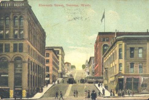
Read more about the Tacoma Railway and Motor Company in an interesting article from The Street Railway Journal. This illustration shows a cable car climbing the Eleventh Street hill. (Source: "Portland, Tacoma, Seattle, Everett, Astoria," The Street Railway Journal, May, 1893. Volume IX, Number 5.) March, 2013 Picture of the Month. |
line: Loop. A Street from 13th to 11th. Up 11th to K. K to 13th. Down 13th to A.
opened: 04-Aug-1891

|
The powerhouse drove the cable and provided electricity for the electric lines. (Source: "Portland, Tacoma, Seattle, Everett, Astoria," The Street Railway Journal, May, 1893. Volume IX, Number 5.) |
powerhouse: 13th and A Streets
grip: Root single jaw side
gauge: 3'6"
cars: Grip and trailer trains. Later closed PAYE.
turntables: N/A
crossings:

|
Looking up 11th Street about 1908. A cable car crosses the path of one of the connecting electric cars. |
notes:
The only US cities to have cable cars after Tacoma were Seattle and San Francisco. Tacoma's one simple line lasted so long because it solved a problem. Like Seattle's Union Trunk Line, the Tacoma Railway and Motor Company's cable line, one of the last to be built in the United States, was meant to be part of an integrated system, connecting electric lines on different levels with the downtown area. Hilton said "If one were to choose the single cable line which was most justified by geographic and economic considerations, the Tacoma installation would be the probable choice."
The Tacoma Railway and Motor Company had no choice but cable traction to reach the higher areas above downtown. The line was busy and successful from the start. The original Stockton grip cars were eventually replaced with metal PAYE cars.

|
Number 87, the last car to operate on Tacoma's single cable car line. There was a good turnout for the occasion. (Source: ""Writing Finis To Tacoma Cable Car History," Tacoma News-Tribune, 08-April-1938, page 1). March 2023 Picture of the Month. |
Cable traction could not be replaced until sufficiently powerful buses allowed the replacement of the whole railway system. The last Tacoma cable car ran on 08-Apr-1938.

|
The crew of Number 87, the last car to operate on Tacoma's cable car line was Conductor George F Aldrich and Gripman FJ Morton. I like the white overalls. (Source: "Writing Finis To Tacoma Cable Car History," Tacoma News-Tribune, 08-April-1938, page 1). March 2023 Picture of the Month. |
A fire gutted the former powerhouse on 16-Feb-1950. Tacoma Transit tore it down the following year.
Some years after cable cars disappeared from Tacoma, Steve's Gay '90s, a restaurant on South Tacoma Way, acquired a motorized former San Francisco cable car and opened its Cable Car Room, which depicted cable cars from several cities, but not Tacoma.
|
Looking up 11th Street. |

|
Looking down 11th Street. |

|
An ad for a Tacoma grocery store, "Where the Cable Cars Stop." (Source: Tacoma News-Tribune, 18-October-1922, page 12). |
Go to top of page.
Butte City Street Railroad

|
A cable car in Butte. Note the condition of the street. June, 2003 Picture of the Month. |
line: Main Street. Main from Galena in Butte to South (Daly Street) in Walkerville.
opened: 12-Apr-1889.

|
Two cable trains pause in front of the powerhouse and car barn. Note the trestlework that carries the line (Source: "Colorado Springs, Salt Lake City, Ogden, Butte, Helena, Great Falls and Spokane", The Street Railway Journal, April, 1893. Volume IX, Number 5.). |
powerhouse: In Centerville.
grip: Vogel and Whalen bottom grip
gauge: 3'6" (probably)
cars: grip and dummy
turntables: At Galena Street. Crossover in Walkerville (?)
crossings:
notes:
Butte was a town built on mineral wealth, first on gold, then on silver, then, most spectacularly, on copper. Butte was also built on the side of a mountain, with the adjoining bedroom communities of Centerville and Walkerville. The population of Butte increased from 4,000 in 1882 to 22,000 1885. All of this created a great demand for public transit.
The Butte City Street Railroad started operating horsecars in 1887, but soon switched to steam dummies. The dummy locomotives could not handle the severe grades, so the company looked for an inexpensive version of cable traction. Low cost was important in installing a cable car line in a city as small as Butte.
The Butte City Street Railroad tried the new Vogel and Whelan non-trust, shallow conduit system. The cable railway trust successfully sued the company for patent infringement. Despite this, the Vogel and Whelan system was a success, requiring a conduit only 10 inches deep. The success of the Vogel and Whelan system in Butte led the Kansas City Cable Railway to convert to its use, and the West Chicago Street Railroad to use it when it converted two of its lines to cable traction.
The company wanted to build a double track line, and the city wanted a single track. The Vogel and Whelan bottom grip could not function with a single track, two-way line, so the company built a gauntlet track with turnouts and two slots. The Vogel and Whelan grip's unique feature of dropping the cable at each stop and easily picking it up again allowed cars going downhill to drop the cable and take the turnouts.
Cable service started on 12-April-1889. The system worked well, but the Butte Consolidated Street Railway, which had taken over the line in 1891, made several efforts to convert it to electricity. Cable service ended on 19-September-1897.
Read about the Butte City Street Railroad in excerpts from "Colorado Springs, Salt Lake City, Ogden, Butte, Helena, Great Falls and Spokane" from The Street Railway Journal, April, 1893.
Butte today is home to Anaconda Copper's abandoned Berkeley Pit, a toxic lake which threatens to overflow and flood the town. There is talk of mining the minerals dissolved in the water.
Go to top of page.
Seattle Visit - 2010
|
|
The famous sign at Pike Place Market. I took the photo at First Avenue and Pike, where the cable cars of the Front Street Cable Railway turned from First to Pike. July, 2010. |
In July, 2010 we took our first trip to Seattle. I wanted to go in order to see the Museum of Flight (excellent), to ride a ferry (well worth it), to ride the monorail (short but interesting) and to see where Seattle's cable cars used to run. Over the next month or two, I will write about the Museum of Flight in my blog, the ferries on my ferryboat site, and the monorail on my Park Trains and Tourist Trains site. Seattle also has a wonderful acquarium. The Hiram M Chittendon Locks and Fish Ladder are also worth a visit. My family had a great time at the Rosalie Whyel Museum of Doll Art in Bellevue. I learned in 2012 that the doll museum had closed. I was sad to hear that.

|
We splurged and stayed at the Alexis Hotel at First Avenue and Madison Street, where the cable cars of the Front Street Cable Railway crossed the Madison Street Cable Railway. It was centrally located and allowed us to walk almost everywhere. July, 2010. |
I tried to show the present-day equivalents of some images from this page.
|
|
In a postcard, a Madison Street single-ended combination car approaches a waiting passenger at the corner of Madison Street and Second Avenue. Also a contemporary view of the same corner with a Metro Transit articulated bus approaching the same corner. |

|
|
|
A postcard shows why cable cars survived for many years on Madison Street. A contemporary view shows that the hill is still steep. |

|
|
|
Looking up James Street from Pioneer Square. Yesler Way is to the right. The iron pergola that served as the terminal of the Union Trunk Line and Yesler Way lines is in the foreground. In the contemporary view, the pergola and James Street are obscured by large trees. The Seattle Hotel was replaced by the Sinking Ship Garage in an ill-advised bit of urban renewal. |

|
|
|
A view from across Yesler Way of the Iron Pergola in Pioneer Square. July, 2010. |

|
A sign at Seatac Airport directs riders to the Sound Transit Link Light Rail station. July, 2010. |
After the first couple of days, I returned our rental car to the airport and took the Sound Transit Link Light Rail train back into town. It was a nice trip, with a mixture of viaducts, tunnels, and street running on private right-of-way. I got off at Pioneer Park Station so I could see the cable car exhibits. Later we took Light Rail to Westlake Station to visit the Nordstrom flagship store and the monorail.

|
Two Sound Transit Link Light Rail trains lay over at the end of the line at Seatac Airport. July, 2010. |
|
|
An exhibit in the Pioneer Square light rail station includes the preserved terminal sheave of the Yesler Way line. July, 2010. |

|
An exhibit in the Pioneer Square light rail station includes an explanation of how cable cars work. July, 2010. |

|
An exhibit in the Pioneer Square light rail station includes a history of the Yesler Way line. July, 2010. |

|
An exhibit in the Pioneer Square light rail station includes the story of the 1990 excavation of the terminal sheave of the Yesler Way line. July, 2010. |

|
Looking down at the Transit Tunnel from the mezzanine at Pioneer Square Station. Metro Transit buses share the tunnel with Sound Transit light rail trains. July, 2010. |

|
We had a nice ride on the Seattle Monorail. Here is one of the two trains, sitting at the Seattle Center Station. See more photos and videos on my Park Trains and Tourist Trains page. July, 2010. |

|
Boats wait in the Hiram M Chittendon Locks. Beyond the lock are the spillway and the fish ladder. July, 2010. |

|
Seattle Fire Department Station 5, with fireboat Leschi. Behind the fireboat is Ivar's Acres of Clams, which was a fun place to eat. Behind the station is the Alaskan Way Viaduct, which will be replaced by a tunnel one day. I took this while standing on ferry Tacoma as it left Colman Dock. See more photos and videos from our ferry ride on my ferryboat site. July, 2010. |

|
Former Seattle Fire Department Station 10 serves as department headquarters and houses a museum which was closed when we visited. The Museum is operated by the Last Resort Fire Department. July, 2010. |

|
King Street Station is Seattle's only active train station. The tower was modeled on Venice's Campanile de San Marco. The station was built by the Northern Pacifc and Great Northern railroads and was finished in 1906. The interior was being restored when we visited. Amtrack trains, including the Empire Builder, the Coast Starlight, and multiple Cascades stop there. Sound Transit commuter trains also use the station. July, 2010. |

|
Union Station, right next to King Street Station, is a former train station, opened by the Union Pacific and the Milwaukee Road in 1911, which has been renovated and made into an office building. July, 2010. |

|
Sound Transit's light rail International District Station is next to Union Station. July, 2010. |

|
A sign marks a crossing of the currently suspended Waterfront Streetcar. July, 2010. |
The George Benson Waterfront Streetcar Line (named after a former Seattle Mayor, not the jazz guitarist) opened in 1982. It ran a fleet of two (later five) Melbourne W2-class trams on former freight tracks on private right-of-way along Alaskan Way. It was later extended on the streets to the International District. The free streetcar ride was very popular until 2005, when the carbarn at the Broad Street end of the line was torn down to build a sculpture park next to the Seattle Art Museum. The tracks and stations are intact and apparently the streetcars have been preserved, but now service is handled by Route 99-Waterfront Streetcar buses, painted to resemble the Melbourne trams. Newspaper articles speculate that the streetcar line may never be restored.

|
Madison Street Station sits empty. A replacement bus on the 99-Waterfront Streetcar sits on the other side of Alaskan Way. Safeco Field stands in the background. July, 2010. |

|
Bus 3248 heads north on Alaskan Way. Note the signs on the side: "Waterfront Streetcar Line" and "Ride Free." July, 2010. |

|
Bus 3247 heads south on Alaskan Way. July, 2010. |
Go to top of page.
Seattle and Portland Counterbalances
Steel wheels on steel rails suffer from limited traction. Many companies in the streetcar era used counterbalances to assist electric cars over steep grades.
San Francisco's Fillmore Hill Counterbalance had one big horizontal sheave at the top of the hill, at Broadway. A cable passed over it and down the conduit under each track. Each conduit had carrying pulleys, like a cable car line. At each end of the cable was a device that protruded through the slot. The downbound car would hook up to the device at Broadway, the upbound at Green. The operators would give their controllers a couple of points to start rolling and the downbound car would counterbalance the upbound. A weighted four wheel dummy hauled out from Turk and Fillmore would balance the last car up at the end of the day. It would sit at the bottom of the hill until the first car went down the next day. Every other trip, the cars would run wrong rail. There was a tender who helped to hook and unhook the car. I have seen a photo of a little shack at the top of the hill.
|
From The Electrician, May 1, 1891. Steep Gradient Electric Traction. -- At Seattle, Wash., a novel method of running electric cars up steep inclines is about to be put into operation. The electric railway there runs up a steep incline about 800ft. long, and it has been found that the motors on the cars are inadequate to surmount it. To overcome the difficulty a small conduit, about 2ft. square, has been constructed, and in this runs a counter-balance car. When an ordinary car is attached to the rope the counter-balance car runs down the hill, but when the passenger car reaches the top of the hill and runs down on the other side, it pulls up the counter-balance, which is now ready to bring up another car. |
Seattle's famous Queen Anne Hill counterbalance, which replaced a section of the Front Street Cable Railway operated on a different principle. There was a conduit under each track, but there was a separate cable and horizontal sheave for each track. Each conduit had rails in it and carrying pulleys. On the rails in the conduit ran a concrete-weighted counterbalance dummy for each track. The device at the other end of the cable, to which the electric streetcar attached, was called a "shoe". A "hookup man" attached the shoe to the car and the motorman started rolling. The descending or ascending dummy matched the weight of the car. Most sources say that a block or two of cable conduit was retained at the bottom and filled with sawdust to cushion the dummy in case it ran away. The cars would still have to run wrong rail half the time.
|
From Electrical West, October 12, 1907. Seattle, Wash. -- The Seattle Electric Co. was given a permit to construct a new steel and concrete counterbalance to take the place of the wooden one on the east tracks of the Queen Anne Hill line. The Board of Public Works almost decided to refuse the permit until next March, but as the company has arranged to take care of the East Queen Anne traffic by way of the Cedar Street line, it was decided to allow the street to be torn up this winter. The company is getting ready to operate its big cars on the hill, and will double the lifting power of the counterbalance. "Y's" were authorized by the Board, to be built on the new Nineteenth Avenue line, on the Fifteenth Avenue north line, and on the extension to the Wallingford Avenue line at Sixty-fifth Street and Latona Avenue, in order that the big cars could be put in operation on those lines. |
The major difference is that on Fillmore, the streetcars counterbalanced each other, while on Queen Anne each car was independently counterbalanced by its own dummy. That might have been a little more flexible.
|
From The Hudson Triangle, February 24, 1917. The The Hudson Triangle was a publication for dealers and drivers of the Hudson Automobile. The Super-Six was a Hudson model.
Seattle's Steepest Hill ConqueredTo carry seven passengers over Queen Anne, Seattle, Washington's steepest hill, counterbalance in high gear, was considered an impossibility until it was accomplished late in October by a Hudson Super-Six. No other motor car has ever duplicated the feat. The test was arranged by S. F. Moseley of the Northwest Motor Co., distributers at Seattle. One of the local Super-Six owners, N. C. Healy, used his car and selected six passengers, including the automobile editor of the Seattle TIMES. At a given signal the Super-Six shot over the level to the foot of the hill at 45 miles an hour. This speed was maintained for quite a distance till a grade of 18.5% was encountered. The summit of the hill was reached at 20 miles. Not content with this impressive achievement, Mr. Healy, to show the grade-eating proclivities of his car, asked the passengers to step out. He then turned the car down the incline paralelling the counterbalance. On arriving at the bottom, he turned at an acute angle and, without any start to speak of, shot up the hill. He entered the slope at about 15 miles an hour and went up all the way in high gear without difficulty. With one passenger in the car he repeated the climb of the counterbalance on high gear, beginning the ascent at 32 miles an hour and losing but 6 miles on the climb. Then, to convince the beholders of these feats that the Super-Six was not geared to make these ascents, he took 3 passengers out on a wellknown Seattle road and drove the car at a speed of sixty-six miles per hour. These tests created amazement in Seattle after the editor of the TIMES had spread them in display stories in his paper. The Northwest Motor Co., printed a big advertisement of the Super-Six, which contained the TIMES editor's sworn affidavit to all the performance above related. |

While the Queen Anne Hill counterbalance is remembered by many, Seattle had three other less well known counterbalances.
The Rainer Avenue Electric Railway, which received its franchise on 21-July-1891, went from the foot of Washington to 16th Street (14th Ave South), to Jackson, on private right of way to the southern city limit. To climb a 16-17% grade on Washington, it used a counterbalance arranged like Queen Anne Hill, with iron cars running in the conduit. They were cushioned at the bottom by a pneumatic cylinder rather than sawdust.
The counterbalance, which was a bottleneck, was abandoned on 05-Apr-1910 and the electric line was rerouted on 14th Ave South at King to Fifth Avenue to Main to Fourth Avenue to Stewart Street. The Main and King section was rerouted again to Dearborn in 1917, and the whole operation was replaced by buses on 01-January-1937.
The Seattle Central Railway, which was sold to the Seattle Electric in 1903, soon after it opened, used a counterbalance on Main.
I was most interested to learn about the Washington Hotel Counterbalance, which ran three blocks on a 20% grade from Pike Street to the entrance of the hotel on Denny Hill. The line opened in the mid 1890's and was Seattle's shortest electric line. An electric car, 174, later renumbered 139 by Seattle Electric, ran on a track parallel to a track with a weighted car, which provided the counterbalance. The line was abandoned in 1907, as part of the great regrading project.
|
From Electrical Engineer, July 19, 1893.
Kuhlmann's Counterbalance System Of Operating Electric Cars on Steep Grades.It frequently happens in locating an electric street railway line that there will be one or two places where for a short distance the street grades will necessitate a track grade too great to be easily overcome by ordinary motor power without danger of injury to the mechanism, while the grades on the remainder of the line will be quite easy. At such places a simple device for furnishing additional power to overcome the grades can evidently be used to advantage. The device illustrated herewith is the invention of Mr. J. P. F. Kuhlmann, a civil and mechanical engineer of Seattle, Wash., and is the solution of the problem which confronted him in building the Ranier avenue electric line down the steep hill to the water front on Washington street, in Seattle, Wash. Subsequently it was used with some improvements on the Front street line, of the City and West Portland Park Motor Line, in Portland, Ore. On the Washington street line the grades between South Fifth street and South Eighth street, for a distance of 1,000 feet, are 11, 14 and 16 per cent., respectively. Evidently the electric cars could not descend these grades safely with nothing more than the ordinary wheel brakes to restrain them, and unusually heavy motors would be needed to surmount them. A cable-road was obviously too expensive for such a short piece of line, so that some economical device had to be found to aid in the ascent and to check the descent. The plan devised was to operate a counterbalance weight running in a conduit underneath the track. This conduit was three feet wide and 18 inches deep, and is shown in section in Fig. 1. In it two weights aggregating six tons run on a track. To one end of these weights is attached a 3/4-inch wire rope and to the other a 5/8-inch rope, which runs in a smaller conduit on the inner side of the right hand rail. Upon reaching the top of the grade on its way down the car picks up the dummy rope in the small conduit by being coupled to a bar projecting about 8 inches from the ground, and in descending hauls up the weights, thereby checking its speed so that the wheel brakes will hold it if necessary. A car going up the hill is coupled in the same manner, and by means of the electric power starts the weights from the level at the top, which in descending aid in pulling the car up the grade. When the weights reach the foot of the grade and are released, any shock is avoided by means of a pneumatic buffer composed of 8-inch wrought iron pipes, in which 7 (? - JT)-inch pistons work. On starting up the hill the weights pull out the pistons by means of a finger which is released automatically, similar buffers are situated at the top of the grade. It may be stated that the weights exactly balance an empty car, and the motor has to overcome the weight of the load only. The line as thus constructed was put in operation on Aug. 28, 1891, and has worked with uniform success since in the Front street line of the City & West Portland Park Motor Co.'s line, in Portland. Ore., however, the system has been improved in many particulars. The details of the mechanism at the upper and lower endings of this line are shown in Fig. 2. This line runs up Front street, for a distance of 550 feet from the Southern Pacific R. R., crossing to Thomas street on a grade of from 12 to 14 percent., and the need of some device for quickly stopping the cars is enhanced by the fact that the railway crossing is on a curve on a bridge just as the road leaves a side hill cut, making it impossible to see the trains coming.
For this line the main conduit was made the full width of the track, 43 inches wide, and 14 inches deep, with the smaller conduit, 6 inches wide and 8 inches deep, in which the dummy rope runs, directly above it. This arrangement may be seen from the section, Fig. 2. The principal improvement is in the coupling device which is inserted in the guard at the lower end of the car. The car on arriving at the lower end of the grade is stopped about 4 feet above the point where the coupling tongue is located. This tongue, which forms the connection with the cable, is then raised above the slot by a lever located at one side of the track. The car is then allowed to run backward by gravity and to couple itself automatically. The current is then applied starting the car, and. through the tail ropes, the weights at the upper end of the grade. When the car arrives at the upper end, the conductor pulls a cord which disengages the tongue, and it proceeds on its journey without stopping. On the down trip the tongue, which projects from the slot and is protected by a swelling in the roadbed, connects automatically with the car, making it impossible for it to descend the grade without pulling up the weiehts. At the lower end the conductor steps off the car and by raising the lever disconnects the car from the tongue. This coupling device requires the car to stop but once on the round trip, but it has to slacken speed for all connections and disconnections. On the Seattle line the coupling consists of a forked drawbar, in which the tongue attached to the dummy or the weights is fastened by a pin. This line also has safety brakes connecting the weights which act instantly in case the rope breaks, but these are dispensed with at Portland as unnecessary, and so also are the pneumatic buffers at the upper end, as the connecting tongue is so arranged that the weights cannot move after the car disconnects. The weights on this line are 6 1/2 tons. Mr. Kuhlmann states that he has carried as many as 95 passengers at a speed of seven miles an hour on the Portland line, and that twice a day a freight trailer is attached to the motor and is moved with ease. A fuse rarely blows out, and then only when the voltage falls low on account of insufficient feed wires. He is satisfied by experiments that if the counterweight is made 25 per cent heavier than the empty car, a grade of 20 per cent, may be overcome and 75 passengers carried with the same motors and at the same speed. Two weights are used to follow the change in grades more easily, and when small single-truck cars are run only one need be used, the other being left at the upper end of the grade. |


Portland's City and West Portland Park Motor Company operated a Kuhlmann counterbalance on a stretch of 16 percent gradient on its Front Street line starting 28-August-1891. "This line runs up Front street, for a distance of 550 feet from the Southern Pacific R. R., crossing to Thomas street on a grade of from 12 to 14 percent., and the need of some device for quickly stopping the cars is enhanced by the fact that the railway crossing is on a curve on a bridge just as the road leaves a side hill cut, making it impossible to see the trains coming." (Source: "Kuhlmann's Counterbalance System Of Operating Electric Cars on Steep Grades.," Electrical Engineer, 19-July-1893.)

|
Read more about the City and West Portland Park Motor Company counterbalance in an interesting article from The Street Railway Journal. This illustration, looking up the great trestle from the powerhouse, comes from the article. (Source: "Portland, Tacoma, Seattle, Everett, Astoria," The Street Railway Journal, May, 1893. Volume IX, Number 5.) February, 2013 Picture of the Month. |
Go to top of page.
Steve's Gay '90s (Tacoma)

|
A postcard showing Steve's Cable Room, with cable car booths, and the Gay '90s room, with "surrey with a fringe on top" tables. |

|
An opening day ad for Steve's Cable Room. "Dipped Potato Chips" sounds interesting. (Source: advertisement, Tacoma News-Tribune, 08-July-1954, page 9). |
Steve's Cafe, commonly called Steve's Gay '90's, was a popular Tacoma restaurant from 1950 to 1977. The 1954 Tacoma City Directory described Steve's, located at 5238 South Tacoma Way, as a "Smorgasbord of American Dishes Served in an Atmosphere of the Gay 90's".

|
A booth in Steve's Cable Room decorated to resemble a Tacoma cable car. (Source: advertisement, Tacoma News-Tribune, 08-July-1954, page 8). |
In 1954, co-owner Steve Pease added "Steve's Cable Car Room", with booths shaped like the front ends of cable cars, which were labelled for Powell Street, Angel's Flight, Yesler Way, Tacoma's own cable car line and others. The Cable Car Room was designed by Bill Knabel Sign & Display Service.
Other rooms included the Golden Era Cafe, the Opera House, the Gay Nineties Smorgasbord and the Memory Lane Banquet Room.
Steve purchased former California Street Cable Railroad car 46 which had been motorized. He drove it up the coast and used it for events like the Daffodil Parade. The car is currently operated by San Franciso's Cable Car Charters.

|
Cal Cable car 46 being delivered to Steve's Gay '90s. |

|
Cal Cable car 46 with entertainers from Steve's Gay '90s. |
Ron Gates has visited Aversano's, an Italian restaurant in Sumner, WA. The cable car booths are preserved there.

|
Cable car booths from Steve's Gay '90s, preserved at Aversano's Restaurant in Sumner, WA. September, 2003 photo copyright Ron Gates, all rights reserved. |

|
Detail of California St Cable R.R. Co 56 cable car booth, preserved at Aversano's Restaurant in Sumner, WA. September, 2003 photo copyright Ron Gates, all rights reserved. |

|
Dash of "O'Farrel Jones, and Hyde 56" booth, preserved at Aversano's Restaurant in Sumner, WA. September, 2003 photo copyright Ron Gates, all rights reserved. |

|
The Olympic Pickle Company offers good wishes to Steve's Cable Room on its opening. I like that name. (Source: advertisement, Tacoma News-Tribune, 08-July-1954, page 8). |
Go to top of page.
The Skagit Incline

|
A car of the Skagit Incline carries tourists. Note the tracks on the platform. July, 2003 Picture of the Month. |
The Skagit River Valley lies about 140 miles northeast of Seattle. Under the leadership of JD Ross, municipal utility Seattle City Light built a series of projects in the valley to provide hydroelectric power to the city. In 1920, Seattle City light completed the 23-mile long Skagit River Railway from the Great Northern at Rockport to the site of the Newhalem Creek powerhouse and Gorge dam in the Skagit Valley. The line was operated with steam locomotives and rail buses. City Light began organizing two-day tours of the project in 1926; the tours helped to show the public the importance of the project.
When they extended the railway 9 miles to the site of Diablo Dam, City Light used electric traction to cope with the heavy grades and sharp curves. An incline on Sourdough Mountain connected the bulk of the electric division with a quarter mile segment that reached the shore of the new lake which formed behind the dam.
The 600 foot electrically powered incline used two cars which ran on three pairs of standard gauge rails. The platform car had a truck at each end which ran on the outer pair of rails. Rails on the platform car could carry a standard gauge railcar up and down the incline. A four-wheeled counterweight car ran on the middle set of rails. At the halfway point, the middle rails dipped to allow the platform car to pass over the counterweight car.
The incline opened in 1928 and became a popular part of the tours in 1930. Skagit Dam and powerhouse were completed in 1935. Work started up the canyon on Ross Dam. This required railcars to be barged two at a time along the lake and hoisted up another incline.
Tours stopped during World War II, but resumed again after Ross Dam and powerhouse were finished in the early 1950's.
The Skagit River Railway was abandoned in 1954, when plans to raise the Gorge Dam would have flooded most of the electric line. The incline is still used to haul equipment. Because of the current security concerns, tourists may not visit the incline or Diabolo Dam.
Visit the Skagit Tours site.

|
Diabolo Dam under construction, circa 1930. Note the surrounding terrain. |
Go to top of page.
Selected Items from The Street Railway Journal
|
|
|
|
|
|

|
Reference was made in a former issue of the STREET RAILWAY JOURNAL to an ingenious system of counterweights in use on the Rainier Avenue Electric Railway, of Seattle, Wash., for assisting electric cars in the ascent of a steep grade on that line. The accompanying diagram will show the general arrangement of the system. A slotted conduit about two feet in height is constructed under the track of the railway, and in this is located an endless rope running over end sheaves at the top and base of the incline. To this rope are affixed rolling weights, B and B1, which run on a track in the conduit provided for the purpose, and at each end of the incline are air buffers for reducing any sudden jar which might be caused by the sudden stoppage of the rolling weights. These air buffers consist each of a cylinder and piston, which latter carries at its outer end a small pawl for engaging in a notch at the end of the weight. A suitable gripping device is located on the car, by which a firm hold can be kept on the cable while ascending or descending the grade.
The operation of the device will now be easily understood. When the car is about to descend the grade, as shown, the weights will be at the foot of the incline, the buffer piston within the cylinder and the pawl in the detent at the end of the lower weight. As the car pulls on the cable the weights begin to ascend, carrying with them the piston of the air buffer, and allowing the cylinder to fill with air. When the piston is fully drawn out the pawl, which connects it with the weight is automatically disengaged, thus leaving the cushions adjusted to be used as the weights descend again. As the car continues down the grade the force of the ascending weights tends to counterbalance the weight of the car, and when the latter finally reaches the bottom of the grade, the weights have been drawn to the top and are resting on the level which is formed for them and engaging the cushioning device. They remain here until a second car arrives at the foot of the incline, which, as before, connects with the cable, and starts the weights down the grade, and brings the force of the weight into play to assist in pulling the car up grade. A brake is located between the weights, and is arranged to work automatically in case the speed of the weights in ascending or descending should become excessive. The inventor of the system is J. F. P. Kuhlmann, of Seattle.
Go to top of The Electric Railway Journal section.
Go to top of this page.
|
|
|
| FIG. 17. -- CABLE POWER HOUSE -- BUTTE CONSOLIDATED RAILWAY. |
The cable line was started in 1888, and was built to develop the Vogel & Whelan cable system, a bottom grip and shallow conduit being employed. The line is built along the principal street, running up and down the hill and extends in nearly a straight line to Walkerville, near the summit of the mountain. The maximum grade is 13.2 per cent. It is a three-rail road with turn-outs at suitable intervals, and although a very cheap construction, having the slot rails spiked to timbers, it is standing up remarkably well under the traffic. The speed of the rope is six miles an hour, and it is supported on carrying sheaves seven inches in diameter. The .conduit being shallow and the carrying sheaves small, the noise from the running rope is very audible on the street. Curve pulleys are about one foot in diameter and are placed very near together, and at several points over the first hill depression pulleys are employed. A portion of the line near the upper end runs over private property, and there are a number of trestle bridges which cross the ravines and gorges of the mountain. A one and one-eighth inch rope of the Hazard manufacture is employed and has a life of about eighteen months.
The cars are run in trains consisting of a grip and trailer. The middle portion of the grip is housed in with glass windows, and makes a very comfortable cab for the gripman, which is quite essential in this cold climate. The grips, and most of the trailers, were manufactured by the Brownell Car Company. The company also employs two open grip cars for summer service, which were manufactured by the Woeber Brothers.
At the lower terminal of the line a turntable is employed, and tracks are drawn together and so arranged that the grip is first run on to the table and turned partially around, when it takes the rope and is drawn a short distance up the track. The trailer is then run on the table by gravity, turned, and the grip drops back and couples to it. At the upper end there is a double crossover on a steep grade. The grip, after reaching the end of the line, is uncoupled from the trailer and drops down over the first crossover and halts, when the trailer is let down by gravity over the second crossover and is coupled on. The trains are operated in winter on a ten minute headway. All the turnouts are located on the down track and on the grades, so that at each the rope is dropped, and the train passes over by gravity. This avoids the necessity of providing curve pulleys for leading the rope to one side. The grip dies are made of metris metal, and have a life of from twenty-five to thirty days.
The cable power station is located about half way on the side of the mountain, as shown in Fig. 17. It consists of the boiler room, engine room and car house. The rope is driven by the S method, two drums with interlocking gear being employed, around which the rope makes one wrap, and which are driven by thirty inch pinions on the main shaft, which mesh into the gear on the outside of the first drum, as shown in Fig. 18. This method of drive, it is claimed, is giving very good satisfaction. Only one engine is employed, and this is a 125 H. p., manufactured by the E. P. Allis Company. The steam is generated in two boilers of eighty horse power each, manufactured at the Ames Iron Works, of Oswego, N. Y. The tension weight is graduated, extra cast iron plates being held in position on shelves from which they are lifted or returned as the car runs out or in. A total weight of about eight tons is employed. Sometimes when all the load is on the down grade the rope drives the engine, no steam being required.

|
| FIG. 18. -- INTERIOR OF CABLE POWER HOUSE -- BUTTE CONSOLIDATED RAILWAY. |
EMPLOYES.
The pay of conductors, pilots and trackmen is $3 per day. These rates are miners' wages and are regulated by the labor organizations. The company has been very fortunate in securing a very good class of men, some of whom have been in the employ of the company ever since the lines were started. The manager finds, however, that, when his men get a little careless, by laying off or discharging one or two, it straightens up the whole force.
The usual rate of fare is ten cents. On short sections of the cable road it is five cents and a five cent fare morning and evening is made for the workingmen. In the opinion of the manager, a uniform fare of five cents over all the lines would bring a greater revenue to to the company than the present rates, and probably a trial of this rate will be made in the near future.
At the steam railway station the conductor leaves his car and goes on a platform where he announces that the street cars are in waiting and that they pass the principal hotels. By this means a great deal of transient patronage is secured. The cars are warmed with the Standard stove, which is giving excellent service. Local inspectors are chiefly employed, but sometimes, men sent out from Thiels Detective Agency, of Portland, are engaged.
The portable register manufactured by the International Register Company, of Chicago, is employed. Slack Coal costs $3.65 per ton delivered to the electric power house and $3.90 per ton at the cable power house, it being necessary to haul it to the latter station by wagons.
Spokane, Wash.
From the tower of the Spokane Review building an excellent panoramic view is had of this "Magic City," located near the border of the lovely Spokane Valley which is like an amphitheatre regularly scooped out, and bordered by low, pine clad hills picturesquely broken up by cliffs of basaltic rock, and backed by high ranges of snow clad mountains to the north and east. Just back of the city, and up which the city is climbing, is a high ridge which is strewn all over with numerous basaltic boulders interspersed with a luxuriant growth of pines, and which is coming to be the favorite residence portion of the city. Here and there, where the space between the rocks will allow.stand beautiful homes, from which vantage ground a full sweep of the entire valley is had. The surface of these dark colored boulders, which in some cases are as large as a house, is seamed and rent into an infinite number of irregular shapes, which are so wedged and interlocked that the contour of the boulder is preserved, but which appear to be so loosely united as to be readily broken up by the use of a hammer or pick.
The chief practical feature of this charming valley is the Spokane (pronounced spo-can) River which has its source in the Coeur d'Alene Lake, a sheet of water thirty-two miles distant, covering an area of seventy square miles. From this lake it flows through gravelly plains until it reaches the very heart of the city where it encounters irregular masses of basaltic rock by which it is broken up into numerous distinct channels, with numerous falls and whirlpools. These again unite in a single channel and dash furiously down a series of cascades with a descent of 130 ft., from the foot of which the river flows away into a dark and tortuous canyon until it is lost to sight, a mile below.

|
| FIG. 25. -- SPOKANE FALLS AND RAILWAY POWER STATION. |
From the Monroe Street Bridge (Fig. 25), which is 160 ft. above the river bed, a most delightful view is had of these magnificient falls which, it is claimed, have an available force of 36,000 H. P., a dower which any city might envy.eter, and carries a seventeen inch pulley which revolves at a speed of 1,000 revolutions per minute. The shaft pinion is belted to a thirty-eight inch pulley on the countershaft and from the countershaft by means of a twenty inch pulley, power is transmitted by a belt to an eight foot pulley on a second shaft, which, by means of a twenty inch, staggered gear pinion, drives the first winding drum, the winding drums not being geared together.
But the expectations of its citizens, as to the future greatness of this city, are not based upon the water power alone, but because it is the metropolis of an inland empire embracing Washington, northwestern Oregon, southern Idaho, western Montana and southern British Columbia, having a population of 250,000 people, and a wealth of mineral, agricultural, grazing, timber and climatic resources which are as matchless as her water power.
The city has a present population of about 30,000 and, in addition to being delightfully located and an important railroad center, it will outrank many Eastern cities in the line of public improvements, business blocks, bank buildings, school and church edifices.
STREET RAILWAYS.
Most of the street railways of the city are controlled by the Washington Water Power Company, the same parties composing the Spokane Street Railway Company, under which name the lines are operated, Wm. S. Norman being general manager, and which embrace twenty-five miles of track, twenty-two of which are operated by electricity and three by cable, and which last year received a patronage of 1,680,959 people. Both Edison and Thomson-Houston motors are employed. There are also three other companies which operate suburban lines, one known as the Spokane & Montrose Motor Company, which employs four cars with both Thomson-Houston and Short motors; the City Park Transit Company, which operates five motor cars, and the Arlington Heights Street Railway Company. All the lines combined carried the entire population about seventy-onetimes. The power for operating all the lines is supplied by the Washington Water Power Company. All the generators and the cable line are driven by water power. The power station is located on the right bank of the Spokane River, below the falls (as shown in Fig. 25) which is reached by wooden stairs built against the almost perpendicular banks of the river. The water is taken from the dam at the second falls and is conveyed in a pair of seven foot steel penstocks a distance of 500 ft., and which are shown above and in the rear of the power station, the total fall from the dam being seventy feet.
The power station is a brick structure, 60 X 120 ft., and two stories in height. The penstocks are led along the first floor near the center of the building side by side, and the Victor horizontal turbines, which are manufactured by Stilwell & Bierce Company, of Dayton, O. -- a type of which is illustrated in Fig. 26, by which the power is generated -- are connected by branches to the right and left, and the axles of the wheels are twenty feet above the tail race. The vacuum fall produces the same power as if the wheels were placed at the lower level. The generators for the street railway work are driven by twin wheels seventeen and a half inches in diameter, having a capacity of 400 H.P. The outer shell is about six feet in diameter, and the discharge pipes are three feet each. The cable winding drums, which are also located on first floor of the power station, are driven by means of belting and countershafts by a fifteen and a half inch twin wheel, the shaft of which is two and a half inches in diameter, and carries a seventeen inch pulley which revolves at a speed of 1,000 revolutions per minute. The shaft pinion is belted to a thirty-eight inch pulley on the countershaft and from the countershaft by means of a twenty inch pulley, power is transmitted by a belt to an eight foot pulley on a second shaft, which, by means of a twenty inch, staggered gear pinion, drives the first winding drum, the winding drums not being geared together.
The tension run is placed at right angles to and in the rear of the power station, and the ropes, supported by suitable sheaves, are led along under the suspension bridge to the right, and up the bluff a distance of 500 or 600 ft, where they are led into a conduit, a seven-eighths inch rope being employed. Two sets of winding drums are provided, both mounted on the same shaft, but only one rope is driven, as that portion of the cable line on which the second rope was employed, has been changed to electric traction. When the cable lines were first built both ropes were driven from a small station located on the opposite side of the river from the present plant, the penstock for operating which still remains and is shown to the left of Fig. 26.
The entire wheel equipment of the station is 2,000 H. P., there being eleven pairs of turbines; one of these is a 400 H. p., twin, horizontal wheel, three are 300 H. P., and there are seven pairs of ten inch wheels of 160 H. P. eacli. The maximum capacity of the two penstocks is 2,700 H. P. A Snow governor is employed on the wheels that drive the light generator, but this is not found sensitive enough to regulate the power wheels, and a governor manufactured by A. W. Woodward, of Rockford, 111., has been installed. This governor employs a set of friction disks which transmit the power from a running shaft to a controlling valve. This governor, we are told, is giving better satisfaction than anything heretofore tried, but it does not fully meet the difficulties.
All the wheel cases in this station are provided with pipes and by-pressure valves, by means of which the cases can be filled, thus relieving the pressure on the gates so that they can be easily opened for starting. The cases are also provided with pipes for the escape of the air when they are being filled, and the main penstocks are provided with stands which serve as air chambers to relieve the shock when the flow of the water is checked.
EMPLOYES.
The conductors and pilots are paid twenty-two and a half cents per hour; track laborers $2 per day. There is no sliding scale of wages. The company has had no strikes.
CABLE LINE.
The cable line is a double track road, and was built in 1889, under Howard C. Holmes, of San Francisco, as chief engineer. A portion of the line is on a grade of 7 1/2 per cent. Traffic being light, only two cars are employed. This, we believe, is the only cable road in the country that is operated by water power.
Go to top of The Electric Railway Journal section.
Go to top of this page.
|

|
The cable line operated by this company is a double track road with a three and a half foot gauge, embracing seven and a half miles of track, including two branches, one on Jefferson Street, recently constructed, which runs to the City Park, but which is operated only in summer. A second, on Alder Street, which runs between the main line on Fifth Street and the river, the main rope being deflected to operate the cars on this branch. It was opened for traffic in February, 1890, but, being unfortunately located, has never enjoyed a very liberal patronage, the number of people carried last year only amounting to 1,260,000. The road was built by the Pacific Cable Construction Company, of San Francisco, under the direction of J. M. Thompson, engineer. The road is now operated under the management of F. I. Fuller, who is also acting as receiver. There are a number of curves on the main line, and where the grade is suitable the cars round the curves by gravity, which results in considerable saving on the rope. Depression pulleys are also employed at several points, and these consist of two six inch grooved wheels which are mounted near the end of a long lever, which is pivoted and held in position by a weight, but which is pushed to one side by the grip shank as it passes.
|
|
| FIG. 8. -- POWER HOUSE AND 20 PER CENT. INCLINE -- CITY CABLE RAILWAY CO., PORTLAND. |
The line has many interesting features both as to construction and operation. The yokes, illustrated in Fig. 7, are of wrought iron, and the conduit walls are of concrete, six inches in thickness. On some of the latter construction, however, the concrete walls were considerably strengthened. Although there is little frost in this climate, considerable trouble is had from slot closing in cold weather, so that it is frequently necessary to wedge open the slot to provide space for the grip shank. The original carrying pulleys were about eight inches in diameter, and were mounted in the conduit without any pulley vaults. More recently, however, twelve-inch pulleys have been employed, but it is the intention of the manager to substitute ten inch pulleys, as the accumulation of water in low places, during wet weather, retards the operation of the large wheels.
|
|
| FIG. 9. -- WOODEN TRESTLE, 20 PER CENT. GRADE -- CITY CABLE RAILWAY CO., PORTLAND. |
On Chapman Street the road scales a high bluff by means of a high trestle 1,300 ft. in length with a grade of 20 per cent. (Fig. 9), and continues above the trestle for a considerable distance over steps ranging from 12 to 20 per cent., making a rise of 450 ft. in a distance of 2,600 ft., the terminal being 600 ft. above the river. From the highest point the road turns to the right and runs along the mountain for a considerable distance to the terminal, where is located a turntable on which the cars are turned by hand for the return trip. It was the intention of the original promoters to continue the line to the top of the mountain some little distance beyond, but the section has never been completed.
The cars, twenty-three in number, are all eight wheel combination, one of which has an open section at both ends. The cars are carefully designed and tastefully finished, and were manufactured by the S. C. H. & A. Works, Stockton, Cal. (Fig. 9). The deck lights are in two rows, the lower being constructed with stained glass in fixed frames, while the upper has ordinary glass with ventilating sash. The curtains are housed in a hood or circular moulding, and the end lights are composed of circular reflectors. The hoods, as will be noted from Fig. 9, are provided with a water ledge and eaves pipe which carries off the rain water and prevents it from dripping upon the platforms.
A bottom grip is employed, which was invented by Mr. McLellan, one of the employes of the company. The jaw is twelve inches in length, and grip dies of wrought iron are employed which have a life of about three weeks. The grip is operated by hand levers from the open portion of the car and is provided with an adjustable mechanism which always insures a firm hold on the rope. The grip has operated with great satisfaction and has never failed even on the heavy grades.

|
| FIG. 10. -- CONTINUOUS ROPE TRANSMISSION -- CABLE POWER STATION, PORTLAND. |
The power station (Fig. 8) is located at the bottom of the incline, and is a wooden structure 110 x 152 ft., including the car house. The power equipment consists of two Hamilton-Corliss engines of 300 H. P. each, built by Hoover, Owens & Rentschler Company, of Hamilton, O. Both the engines are coupled to the main shaft, but only one of them is employed at a time, the crank rod being uncoupled on the idle engine. The power is transmitted to the driving drums by means of a continuous cotton rope belt with a tension arrangement located as shown (Fig. 10). The drums are not geared together. The rope drive is working in a very satisfactory manner and never has given any trouble except at one time when a new splice was made. The new piece of rope being larger than the remaining portion, gained on the other strands, and the tension weights having been allowed to run down, the slack was not taken up promptly enough, so that the rope dropped out of the groove. It is noted in connection with this drive that the ropes operate equally well after the tension weights have run down, emphasizing the fact that continuous rope drives require but little, if any, tension after the stretch is once taken out of the rope. A force pump, for the purpose of lifting water to the heights above, is operated by means of gears from the main shaft and is located in the station.
Three Lang lay cables, one and one-eighth inches in diameter and aggregating 4,300 ft. in length are employed, and were manufactured by the Washburn & Moen Company. The rope is driven at a speed of eight and a half miles per hour and has a life from eight to twelve months, the longest section having the longest life. The cars are run of a four minute headway in summer and six minutes in winter. The fare is five cents, and the wages of the gripmen and conductors are $2.50 per day for twelve hours' work. The fares are registered by a Beadle alarm punch and trip slip.
The station is provided with a convenient repair shop which is equipped with a number of iron working tools, including a wheel boring machine and a wheel press. The power is supplied by a small steam engine which also runs the generator from which the station is lighted.
STEAM EQUIPMENT.
A double boiler equipment is provided, consisting of four tubular boilers grouped in two batteries of 300 H. P. each, which were installed by the Joshua Hendy Machine Works, of San Francisco. Wood, for the most part, is employed for fuel, although grates are provided, on which coal can be burned, when necessary. Wood is found to be cheaper, however, by $15 per day, than coal which costs $5.50 per ton. The wood is the Douglas fir, or what is known as Oregon pine, and makes a very excellent fuel. It is cut in four foot lengths, and costs, delivered, $3.25 per cord. Wood is used as fuel in all of the principal manufacturing establishments in the city, and also for house heating purposes.
MECHANICAL STOKER.
One of the battery boilers in this station is equipped with a Jones underfeed mechanical stoker which is designed for use when coal is burned. This device not only provides for conveniently handling the fuel, but by means of an underfeed, provides that a fresh fire is always maintained on the upper surface next to the boilers; and by requiring the escaping gas from the fresh fuel to pass through the heated portion, all the heat producing elements are consumed, and it obviates the necessity of opening the furnace door. In the operation of this stoker the coal is fed into a hopper in front of the furnace, whence it drops into a retort, and is forced into the firebox by means of a steam piston, having a fifteen inch stroke, which works in a cylinder just under the floor. The retort consists of a semi-cylinder sloping upwards, so that by the action of the piston the coal is forced upwards, and falls over tuyer pipes upon the grates which are located upon each side of the retort. Air, under pressure, is then admitted through the tuyer pipes, so that the gas liberated from the green fuel is mixed with the incoming air, and passes through the burning fuel above. These stokers are manufactured by the Union Iron Works, of Portland, and they can be installed for about $600 per boiler. The company has recently filled an order for thirty furnaces, for use in the General Electric Company's lighting plant in San Francisco. The device is also applicable to furnaces employing wood fuel, and a model of this kind will be described in another connection.
CITY & WEST PORTLAND PARK MOTOR COMPANY.
|
|
| FIG. 15 -- CAR DESCENDING 16 PER CENT. GRADE BY MEANS OF COUNTER WEIGHT -- CITY &. WEST PORTLAND PARK MOTOR COMPANY. |
... There is one interesting feature in connection with the electric section already completed, and this is the employment of a gravity car which is designed to assist the motor car in ascending and descending a 12 per cent, grade on which the tracks are laid for a distance of about 500 ft. This is a single track road, and the surface of the street on the incline is finished like that for a cable road. In the construction a trench is excavated to a depth of about four feet, the full width of the track, in the bottom of which is placed a narrow gauge track, supported on ties, on the ends of which are placed timbers which support the ties for the surface track and slot rails. This virtually makes a double track conduit in which is placed an endless wire rope supported on small carrying pulleys, and which loops over vertical terminal pulleys, one of which is mounted on a tension car for the purpose of taking up the stretch of the rope. Attached to the rope in the lower conduit is an iron car with small trucks, which is loaded with old iron or rocks, so that it equals the weight of a motor car. An iron shank, which extends above the slot, is attached to the rope in the upper conduit, but at the opposite end of the line from the balance car. The balance car being at the foot of an incline down which an approaching motor car is about to pass, the car is made to engage with the shank, and in its descent moves the rope which hauls the balance car to the upper terminal. The balance car is then locked in position until another motor car is to ascend a grade, when being properly attached to the shank, the balance car is unlocked, and in its descent assists in hauling the motor car up the incline, and also acts as a safety device. The terminals are provided with long air cylinders, to the pistons of which are attached suitable bumpers, upon which the motor car is cushioned in order to relieve the shock of stopping and starting. The device is said to be working in a very satisfactory manner, and is employed on a number of other lines on the Pacific Coast, and will be described in another connection.

|
| FIG. 16. -- UPPER END OF COUNTER WEIGHT SYSTEM, SHOWING CONDUIT CONSTRUCTION -- CITY &. WEST PORTLAND PARK MOTOR COMPANY. |
Tacoma, Wash.
This is known as the City of Destiny, and the residents claim that in a very few years it will lead all the other cities of the Pacific Northwest. The city limits embrace twenty-four square miles, and it is delightfully situated along the shores and on a bluff overlooking Commencement Bay, an arm of Puget Sound, one of the grandest inland bodies of water in the world. From Tacoma it is eighty-four miles due west of the Pacific Coast, but by water through the channels of Puget Sound and the Straits of Juan de Fuca, it is 142 miles. The outlook from Point Defiance, which is the northern terminus of the promontory 01 which the city stands, and which has been chosen for the fine residence district, is superb, embracing both water and mountain views and including the Cascade range of mountains, sixty-five miles to the east and southeast, with its towering, snow capped peaks, including Mt. Tacoma. This has an altitude of 14,444 ft. and with its massive foothills forms a fitting background to the picture which may be regarded as nature's masterpiece, while to the front across the Sound and to the north extends, as far as the eye can trace, the rugged, snow covered Olympic Mountain.
By rail the city is 3,278 miles from New York and is the Western terminal of the Northern Pacific Railroad and other lines, so that here the ocean commerce from Asia and South American ports, which enters the great harbor of Puget Sound, meets the railroads by which it is conveyed to the East and South. This is not only a port of entry, but a distributing point as well for the great wheat, lumber and mineral section which borders on Puget Sound. Lumber is the principal product of the Sound region, and Tacoma has twenty saw mills with an annual output of 300,000,000 ft. of sawed lumber. Most of this timber is Douglas fir, and the trees grow to an enormous size, logs from five to eight feet in diameter being very common. A stick of timber four feet square and 120 ft. in length was recently shipped to Chicago for exhibition at the World's Fair, and timbers two feet square and 120 ft. long are frequently produced on special orders.
TACOMA RAILWAY & MOTOR COMPANY
operates forty-eight miles of track, on two miles of which cable traction is employed and on the balance electric power, and the lines are operated under the supervision of S. H. Pierce.
|
|
| FIG. 17. -- POWER HOUSE OF TACOMA RAILWAY & MOTOR COMPANY -- TACOMA. |
The power for operating all the lines of the city is generated at a single station, controlled by this company and which is located on A Street at the foot of 13th Street (Fig. 17). A charge of $5 per car per day is made for the power supplied to the Point Defiance lines. The power equipment of the station consists of four engines, one of 150 H. P. for driving the cable line, and which is one of the original Corliss engines, having been in service as a saw mill engine more than thirty years. There are also two tandem compound engines of 750 H. P. each, which were built by the Frick Engine Company, of Waynesboro, Pa., and one 300 H. P., high pressure engine built by the Stearns Manufacturing Company, of Erie, Pa.
The main shaft of the compound engine is in a line with the cable shaft to which it may be coupled when necessary. Power for driving the cable drums is transmitted from the pinion of the main shaft, by means of sixteen two-inch ropes, to a large wheel on the shaft of one of the winding drums which are not geared together, but which are equipped with Walker differential rings, and drive the cable with a speed of nine miles per hour. The flywheel on the cable shaft weighs about seven tons, but in the original construction two additional flywheels, weighing seven and a half tons each, were coupled to the main shaft, one on each side of the pinion. Not long since, however, the hub of one of the flywheels broke, when it was discovered that the metal was crystalized, and the superintendent concluded that the flywheels were not acting in harmony, and that the crystalization had been produced by the jerking of one against the other, so he had them both removed, when the plant was found to work more satisfactorily, and the cable had a more steady movement than when the three flywheels were in service.
|
|
| FIG. 18. -- CABLE LINE ON ELEVENTH STREET -- TACOMA. |
The cable line, operated by this company, was opened for traffic in August, 1891, and makes a loop up and down the hill, on 11th and 13th Streets, a number of the grades being as high as 14 per cent. (Fig. 18). Five combination cars, of Pullman make, are run. These are painted a dark color, and have wire dashboards. Dark colored cars, however, are not in favor with the management, and it is proposed to repaint the entire rolling stock in the near future, and finish the cars in light colors. This cable line is one of the best built on the Pacific Coast, and was constructed under the supervision of the late W. B. Knight, of Kansas City, E. Saxton, of Washington, being the contractor.
FARES.
The fare within the city limits is five cents, but on the line to Steilacoom, from the Steilacoom power house near the city limits, it is twenty-five cents, or forty-five cents for the round trip from the city. Transfer tickets are issued between the electric and cable lines, and are bound in pads of about 100, having one or more advertisements of local firms printed on the back. The advertising firms provide the tickets free of charge to the railroad companies. In issuing these tickets the conductor tears the ticket across the face to indicate the hour and minute, and, in place of the straightedge commonly used, he is provided with a clamp ruler which he adjusts to suit the time of the transfer points, so when he is ready to issue the tickets he can tear off any number, even in the dark, without looking to see the time, making it much more handy to issue tickets than when the punch is employed. The stubs remain on the pad, and can be returned to the office. Since this type of ticket and method of issue was employed by the company, the number of tickets has been reduced by about 4,000 per day. Passes are issued to the city officials; policemen in uniform ride free, as also do the mail carriers when carrying their pouches. Passes are also issued to all employes of the company, including the barn and track men, on which they can ride at any time, but are required to show their passes on all occasions. Tickets are sold in lots of twenty one for $1. Transfers are not rung up. Some trouble was experienced by an improper use of transfers by conductors when they were required to register them, but since they are of no value to the conductors their use has not been abused very much. On the electric cars the Lewis & Fowler register is employed, but on the combination cars the Meaker portable register is carried by the conductors. The portable register is employed, because it is not convenient for the conductors to see the dial of the stationary register when he is in the open portion of the combination car.
...
In the operation of the lines it is found that it costs about the same to operate the electric and cable cars. The life of the ropes of the cable line is from six months to a year.
Seattle, Wash.
This is known as the Queen City of the Sound and was named after Se-at-tle, a Suquamish Indian chief who ruled the tribes of this region for fifty years. The city is located on the eastern shore of Elliot Bay, a land-locked arm of Puget Sound, which has an area of about twenty miles, and provides safe anchorage for the largest seagoing vessels.
The streets are regularly laid out up and down and along the slopes of the high promontory upon which it is built and over which it is spreading to the eastward four or five miles to the shores of Lake Washington, a magnificent body of water, twenty miles in length, and from two to five miles in breadth. The shores of the lake nearly parallel those of the Sound, so that the city has two water fronts. The waters of Lake Washington are of great depth, and the mean level is twenty feet above high water in the Sound. There are, besides, two other lakes within the city limits, one known as Lake Union, having an area of two and a half miles, and Green Lake, which is four miles in circumference. There is a project on foot to connect Lake Washington with the waters of the Sound, by means of a ship canal and locks, by way of Lake Union. This will allow sea-going vessels an opportunity to harbor in fresh water when necessary.
Lumbering is the principal industry of this region, and last year the saw mills of Seattle produced $3,000,000 worth of sawn lumber. The city boasts of her commodious homes, while the business blocks and public buildings equal, in design and finish, those in the largest cities of the country. The mountains looming up about the city add a charm to the situation which is unrivaled by any city of the Sound. The principal peak is Mount Rainier, the same which the people of Tacoma have named after their own city, much to the disgust of the people of Seattle.
The principal business streets are paved with fir planking, this being a cheap material in this region, costing only $6 per thousand. This is one of the best favored cities in the country in the matter of rapid transit, having 102 miles of street railway track, or about one and seventenths miles to each one thousand inhabitants, and over which the population were carried last year about 174 times. The street railway systems of the city embrace seventy-two miles of electric lines and thirty miles of cable, and are controlled by nine companies as follows:
MADISON STREET CABLE RAILWAY COMPANY.
The lines of this company, which are under the management of W. B. Goodrich and Superintendent S. Gibson, embrace seven and a half miles of double track cable line on Madison Street, and which starts from Front Street, near the ferry landing, and runs up the heights on Madison Street in nearly a straight line to Lake Washington, where it terminates at a park and the steamboat landing, some of the grades being as high as 19 per cent., and an electric road known as the South Seattle Electric Line, which connects with the cable cars at the foot of Commercial Street and crosses the tide flats on piles and trestle work a distance of five miles, and which is operated by the Thomson-Houston system.
The cable road is a narrow gauge line having a forty-five pound rail, and was constructed by the Pacific Cable Construction Company, J. M. Thompson being engineer.
The power station (Fig. 23) is nearly midway of the line, and in front of it is a turntable on which the cars are run in and out of the station or turned back from this point. There is also a turntable at each of the terminals, which is operated by power from the terminal sheave. The power equipment consists of two 250 H. P. HamiltonCorliss engines which are coupled to the same shaft, but may be operated independently. The power is transmitted to the winding drums by a continuous rope belt, only one of each set being driven, and these are on the same shaft with the receiving pulley. The two ropes are, respectively, 20,100 ft. and 19,800 ft. in length, the town section being run at ten miles an hour and the lake end at twelve miles an hour. The ropes are of the Washburn & Moen manufacture, and are purchased from the San Francisco agent of this company The ropes are one and one-eighth inches in diameter, constructed with six strands, and are guaranteed for a life of eighteen months. A side grip is employed, and the grip dies, last from six weeks to three months, depending upon the weather and the age of the rope. The grips are provided with a chafing plate, which is fastened in front of the shank, and which is about eight inches in length and two and a half inches wide. When worn it can be reversed. This plate takes all the slot wear, so that the shanks proper do not wear out, some being run as long as three years.
The cars are mostly of the combination type, thirty feet in length, and were built by the S. C. H. & A. Works, of Stockton, Cal. There are also a number of open cars with cross seats and center aisle and in winter the cars are provided with a temporary glass front supported in a framework, which the gripmen have put on at their own expense, the cost being about $10. The company does considerable business in handling freight, and a freight car is run over the line three times a day, being hauled by one of the regular trains, the freight being delivered to stores along the line and to the steamboat landing at the lake. The charges for heavy freight are $1 per ton, and the charge for small packages is five, ten, fifteen to twenty-five cents, depending on the size.
The company utilizes its cars for advertising purposes to a greater extent than almost any line we have found. Cards are not only posted in the usual place under the ceiling, but are also hung in the heading, being fastened to the rafters, and each two adjoining cards looped with ribbon at the bottom. Large placards are also hung in the windows on each side, and narrow cards are placed above the windows, also against the end panels of the seats and on signboards suspended from the body outside the trucks. The income from this method of advertising is, doubtless, quite considerable, but the practice cannot be said to add to the beauty of the cars.
All fares are five cents; no transfers are given. School tickets are sold for half price. Messenger boys ride on tickets provided by the telegraph companies, which are received by the railroad company and afterwards redeemed at the office of the messenger service. Policemen in uniform ride free. Mail carriers with their pouches are carried free. No passes are granted to the city officials or the directors of the company. All employes, including the barnmen, ride on their badges at any time, the badges of the barnmen being somewhat different from those of the trainmen.
|
|
| FIG. 19. -- MADISON STREET CABLE RAILWAY -- SEATTLE. |
The pay of conductors and gripmen is twenty-two cents per hour, and the time is reckoned from the time the train starts. They are not allowed anything for the time required for cleaning, taking out and putting up their cars. They are required to report for duty fifteen minutes before leaving time, and they have to sweep their cars and keep their windows clean. The new style of Meaker portable register is employed. Ex-steam-railroad men, in the opinion of the manager, do not make desirable employes, neither do men who have been working a long time for other companies. The managers prefer to break in new men. A bond of $25 is required, and the conductor is required to sign a contract agreeing, among other things, to give seven days' notice of his intention to leave the service of the company, or forfeit the $25 deposited, to be responsible for properly under his care, and attend to his duties with his utmost care and skill. The employes have formed a benevolent association, and each member is entitled to $10 per week in case of sickness or disability. The railroad company is not interested in this association.
At the time of the original construction, the lake end of the route was through new territory, and it was necessary to cut out the forest trees to make room for the line. The company, however, secured considerable territory on the lake front, which it has improved. The grounds have been carefully laid out, shade trees planted, and a large pavilion erected, which is leased for concert and restaurant purposes. There is also a greenhouse with a fine stock of plants, and a number of boat houses have been erected; a bathing pavilion, and a number of attractions have been provided, including a baseball ground near by, as a means of inducing traffic, and frequently, on Sundays, as many as 20,000 people are carried. The company is insured in the Employes' Liability Insurance Company, of New York, for which it pays a certain per cent, on gross receipts.
UNION TRUNK LINE.
The lines of this company embrace ten and three-quarters miles of single track electric railway, and one and three quarters miles of double track cable, over grades varying from 3 to 18 per cent., and are operated under the management of E. F. Whittler, president, and E. B. Hussey, general superintendent.
It was the intention, when the lines were originally constructed, to tow the electric cars up and down hill behind the grip cars, but in attempting to do this it was found difficult to operate the motors in harmony with the cable, so that the drawheads were broken, and passengers became frightened, and it became necessary to abandon the project, so that now passengers have to transfer at the junction.
Two types of cable grip cars are employed. The summer cars are fourteen feet in length, and have the seats facing out, but curved at the ends, making an oval shaped car. The roof is supported by ornamental metal posts, and there is a waterboard all around, roof drainage being provided through the end posts. The winter cars are of the changeable type, but are run as closed cars in the winter, the gripman being housed in a pit at the middle of the car. This car was of local design, and was built by Rohlfs & Schoder, of Seattle. The doors are constructed with glass in both the upper and lower panels, so that the gripman can see the track in front. The seats being filled, the passage through the car is very difficult, on account of the room taken up by the railing about the gripman. It is said that passengers soon become accustomed to the arrangement, and those who are to leave the car between the terminals take the end seats, so that they do not disturb the other passengers in getting out.
The grip lever is reversible, so that cars are run in either direction, and are not turned at the terminals, crossover switches being provided. The lower grip jaw is twenty-one inches in length and the upper fifteen inches. These are now made of refined iron and last about a week. Formerly wrought Norway iron was employed for this purpose. The grip shanks last about a year. There being no curves in the line, they do not wear rapidly.
...
The power equipment, which is located in the basement, as before noted, consists of two 300 H. P. Corliss engines, manufactured by Lane & Bodley, of Cincinnati. The Pond Engineering Company, of St. Louis, designed the plant, and it was built under the supervision of the president of the company. The engines may be coupled to the same shaft by removing the connecting rod. Only one, however, is run at a time. The cable winding drums and the generators are driven from the same shaft by means of a continuous rope transmission, the shaft being provided with a rope pinion and two large rope pulleys placed one on each side of the pinion. From the pinion a continuous two inch rope is led, with seventeen wraps, over a large pulley on the shaft of one of the cable drums which are not geared together, and from each of the large flywheels two inch continuous ropes, making thirteen wraps each, transmit the power to six foot pulleys on the countershaft. Each of the three ropes has independent tension wheels, and that for the cable drum is loaded with a weight of 1,500 lbs. From the countershaft the power is transmitted, by means of continuous ropes, to two Edison 150 K. W. generators and one Thomson-Houston generator of 180 K. W., each of these ropes being also provided with tension apparatus, and loaded with a weight of from 1,000 to 2,000 lbs., the length of the rope influencing the weight. Manilla ropes, which are manufactured by the Portland Cordage Company, of Portland, Ore., are employed.
The cable is run at seven and a half miles an hour, and formerly a one and a quarter inch rope was employed, but since the effort to tow the electric cars was abandoned a one and one eighth inch rope is employed. The first rope had a life of about eleven months. The present rope is composed of six strands of twenty-five wires each, six of them being very fine. The nineteen large wires are laid nine over one and nine over nine, with the small wires interwoven. The tension apparatus is provided at each end of the line, this being considered necessary on account of the steep grades.
Tubular boilers are employed. Both wood and coal are employed as fuel. The wood costs $1.50 per cord, delivered, and coal $2.50 per ton, the latter being obtained from the Black Diamond mines, about ten miles distant from the city. It is thought that the coal is slightly cheaper than wood. City water is used for the boilers. An effort, however, was made to secure artesian water, but after driving a well 700 ft. deep, the project was abandoned.
EMPLOYES.
Trainmen are paid twenty-three cents an hour. The gripmen, after a certain period of service, receive twenty-four cents an hour. Track laborers receive $1.75 a day, and the foreman $2 a day; the head blacksmith $3 a day; the second blacksmith $2.50, and the head car builder $3 a day. A head ropeman is employed, and in splicing he is assisted by some of the gripmen who have been trained for the work, and for which they receive extra pay.
FARES.
The regular fare is five cents, and transfers are issued between the cable and electric lines, and the tickets are provided by a local firm who has its business card printed on the back. The expense of the tickets is about $1 for each three months. These are printed in three colors, with the date and in large type, and are about two and a quarter by four inches, and are bound in pads of 100 each. School tickets are sold for $1 a month, which entitles the holder to ride twice a day on school days only. Transfer tickets are not registered, but the conductors are required to turn them in in the rotation in which they were received. This serves as a check, and if tickets are not found in regular order it indicates that they have received them when they ought not to. Employes of the company are provided with passes which have a blank sheet attached, and which the conductor is required to punch on every trip. Even the president and superintendent are required to present their passes the same as employes. No passes are issued to city officials. Policemen, in full uniform, ride free, as also do mail carriers, when carrying their pouches, and firemen in uniform. Employes' families are not allowed to ride free. This was tried, however, on one line of the city, and on Sundays and holidays it was found that the families of employes filled up the cars to the exclusion of the paying passengers. The International portable register is employed. Only one conductor, however, is employed for three cars. A conductor takes the car at the station, and after riding to a certain point meets the incoming car and collects the fares. In summer, however, one conductor is employed to two cars.

|
||||
FIGS. 21, 22, 23 AND 24. -- POWERHOUSES OF SEATTLE STREET RAILWAYS.
|
SEATTLE CONSOLIDATED STREET RAILWAY COMPANY.
This company now controls the lines which have heretofore been operated under the name of the Seattle Consolidated Street Railway Company, Green Lake Electric Railway Company, Front Street Cable Railway Company, South Seattle Cable Railway Company and Rainier Railway & Power Company, and embraces thirty-three miles of electric lines and ten miles of cable, the system being under the management of D. T. Denny & Sons, with C. S. Clark as superintendent. The company has recently moved into new offices on the corner of Pike and Third Streets.
...
It is the intention of the company to erect one large central station near the mills on Lake Union, so as to operate the lines both of the electric and cable lines from one station, the present plan being to install an electric motor for operating the cable winding machinery. In this new plant compound condensing engines will be employed.
A cable line is operated from the power house on Front Street, from which two ropes are driven, the two sections of line being formerly known as the North Seattle Cable and South Front Street Cable Railway. The plant was designed and constructed by the California Engineering Company, and the power equipment of the cable station consists of two 150 H. P. Frick-Corliss engines, manufactured in Waynesboro, Pa., which may be coupled to the same shaft. The power is transmitted from a six foot pinion on the engine shaft, by a continuous rope belt, to two sixteen foot wood-rimmed pulleys, mounted one each on the shaft of the cable winding drums, so that both drums are driven by the same rope.
An idler is placed near the pinion over which two wraps of the rope are led, which provides space for carrying the second set of wraps past the first to the second driving pulley. One rope is led over an idler and tension pulley attached to the ceiling, to which about 500 lbs. weight of tension is attached. A two inch Manilla rope is employed, and the method of drive is operating very satisfactorily. In the original construction, however, a four foot pinion with ten foot driving drums was employed, but on this the ropes slipped to such a degree as to set fire to the grooves. No difficulty, however, has been experienced since the size of the driving pulleys was increased. In the opinion of the engineer the idler now employed is not necessary, and he thinks the plant would work equally well without it. The speed of the rope is ten miles an hour, and the two sections of rope are 19,600 ft. and 11,000 ft., respectively. A Lang lay type of rope, manufactured by the Washburn & Moen Company, is employed, and the ropes have a life of about twelve months. In the making of this rope, care is exercised that the wires are all drawn in one direction, and in laying up, the twist of the wire, the twist of the strands and the placing of the cable in the conduit are all one way. The conduit on Front Street was constructed with yokes made from old T rails and angle iron, and is about twenty-seven inches deep. That for the North Seattle, which runs to Queen Ann Hill, is all of timber, however, and the method of construction is shown in Fig. 25. The foundation is made of 12 X 12 in. timbers laid across the street to the width of both tracks. Upon this are placed three sections of 12 X 12 in. timbers, and above this stringers, 8x12 in., which support the rails, with two inch planking which forms the walls of the conduit, and supports the surface plank upon which are fastened strips of strap iron to form the slot. This makes a very cheap construction, but unfortunately, not a very durable one. The cable line is operated by grip cars and trailers, and there is also an equipment of combination cars.
SEATTLE CITY RAILWAY COMPANY.
This company operates five miles of narrow gauge cable line, at present under the management of O. S. Buckbee. It is a loop line on which cars are run left handed over grades as high as 15 percent., and the terminals are near Front Street in the city and at Leschi Park on Lake Washington, where are provided the usual attractions for inducing traffic, including a greenhouse, bathing pavilion, dancing pavilion and a managerie of carefully selected animals. The line was started in September, 1888, and is probably the cheapest construction of a cable line in the world, the rails weighing only sixteen pounds to the yard, and the yokes placed eight feet apart with a sheet iron lining for the conduit, the conduit being only thirteen feet deep. The rails are spiked to stringers, and the slot rail consists of strap iron supported also on stringers. The line was built by the Pacific Construction Company, of San Francisco. No drainage is provided, and the diameter of the carrying pulley is about eight inches. The line is operated with open grip cars and trailers, and the trains are run on a headway of from four and a half to ten minutes. The cars are manufactured by the John Hamilton Company, of San Francisco, and by the S. C. H. & A. Works, of Stockton, Cal. A Broderick & Bascom rope is employed, and has a life of from twelve to thirteen months. Several different types of trucks and wheels of different diameters are employed. Turntables are provided at the terminals, and in one street corner of the city in place of a curve, the direction of the cars is changed by means of a turntable upon which the trainmen first push the motor and afterwards the trailer. This method is adopted to avoid the danger of rounding a curve in a busy portion of the city.
The power station is located on the side of a bluff some distance above the lake. Why it was not placed on the shore of the lake, the present manager is not able to explain. As it is, the fuel has to be hauled up from the lake by means of an incline railroad and the water pumped for a considerable distance. The power house is approached from the top of the bluff by a high trestle structure and in its interior construction is very conveniently arranged.
The power equipment of the cable station consists of one Allis-Corliss engine of 250 H. P. and one Hamilton-Corliss of 200 H. p. and two batteries of tubular boilers. The power is transmitted from the four foot pinion on the engine shaft by means of continuous rope belt to driving pulleys on the shafts of the winding drums, both drums being driven. In this transmission no idler is employed, the second set of ropes being led at a slight angle past the first pulley. The tension arrangement consists of a traveling pulley suspended in the well by the rope which passes over two vertical sheaves in the rear of the station; one tension weight of about 450 lbs. is employed. The ropes make six wraps and five wraps respectively on the two driving drums, six wraps being employed on the drum nearest to the engine shaft. The fuel is slack coal, which costs $2 per ton delivered.
Conductors are paid $2.50 per day and gripmen $2.75, trackmen $2.50. The fare is five cents, and no transfers are issued; school tickets, however, are sold at half price. No passes are issued except to employes, which they are obliged to show every trip. The Meaker portable register is employed.
The repair shops at the station are provided with a very complete equipment of iron working tools, including a drill press, lathe, planer and wheel press. Both the repair shop and engine room are kept in an exceptionally neat manner. It is probable the entire line will be reconstructed the coming season.
WEST SEATTLE CABLE RAILWAY COMPANY.
This company, which is under the management of T. Ewing and J. H. Watson, operates two miles of single track of narrow gauge loop line at West Seattle, which is built upon a promontory on the opposite side of the bay, two miles from the city proper and is reached by ferry. The road is built along the side of a bluff next to the water and runs upon the tableland to the power station which is located near the Sound on the west side of the plateau, making fourteen curves in all. The road was constructed by the Pacific Construction Company, and is excellently well built. Combination cars are employed, which were built by the S. C. H. & A. Works, of Stockton, Cal. Only one car, however, is run in the winter time. It makes hourly trips, the line being shut down while the car waits for the ferryboat.
The power station is a handsome wooden structure, and the power equipment consists of one Wheelock 100 H. p. engine with the engine shaft geared direct to one of the winding drums, which is provided with wooden teeth, one drum only being driven. The drums are equipped with Walker differential rings and are mounted upon the foundation frame by adjustable bearings, one set of which is provided with set screws. Steam is provided by two tubular boilers, which were built for the California Engineering Company, this company having designed the plant. A one and one-eighth inch rope of the Hazard Manufacturing Company make is employed. It is about 11,500 ft. in length and has a life of about two years. Wood is employed for fuel, which costs $2 per cord delivered. Fare is five cents; commutation tickets, however, are sold to residents, sixty-two trips for $3, including the ferry to Seattle.
RAINIER AVENUE ELECTRIC RAILWAY COMPANY.
One interesting feature of this line is a balance car construction, similar to that described in connection with one of the Portland lines, and was devised by J. P. F. Kuhlman, by means of which the electric cars are easily operated over a 1,000 ft. line which is on a grade of from 7 to 17 per cent., 300 ft. of which is 16.85 Per cent., 300 ft 12 per cent, and the balance 7 per cent. The balance cars consist of two iron cars having a weight of about seven tons. The construction of this section is somewhat different from that before described, as the conduit is placed at one side of the middle, the balance car occupying the main portion of the space between the rails. The attachment is readily made to the cable of the balance car. Current is used in both ascending and descending, and the balance car not only assists, but also answers as a safety device. In this line the air cylinders are not provided at the top of the grade, but about fifty feet of the top is on level ground where the balance car remains without being locked. The cars are not only run readily over this grade, but frequently haul a heavily loaded freight car.
Go to top of The Electric Railway Journal section.
Go to top of this page.
|